NASA
NASA Science
Mars Exploration Program
Skip Navigation
menu
Images
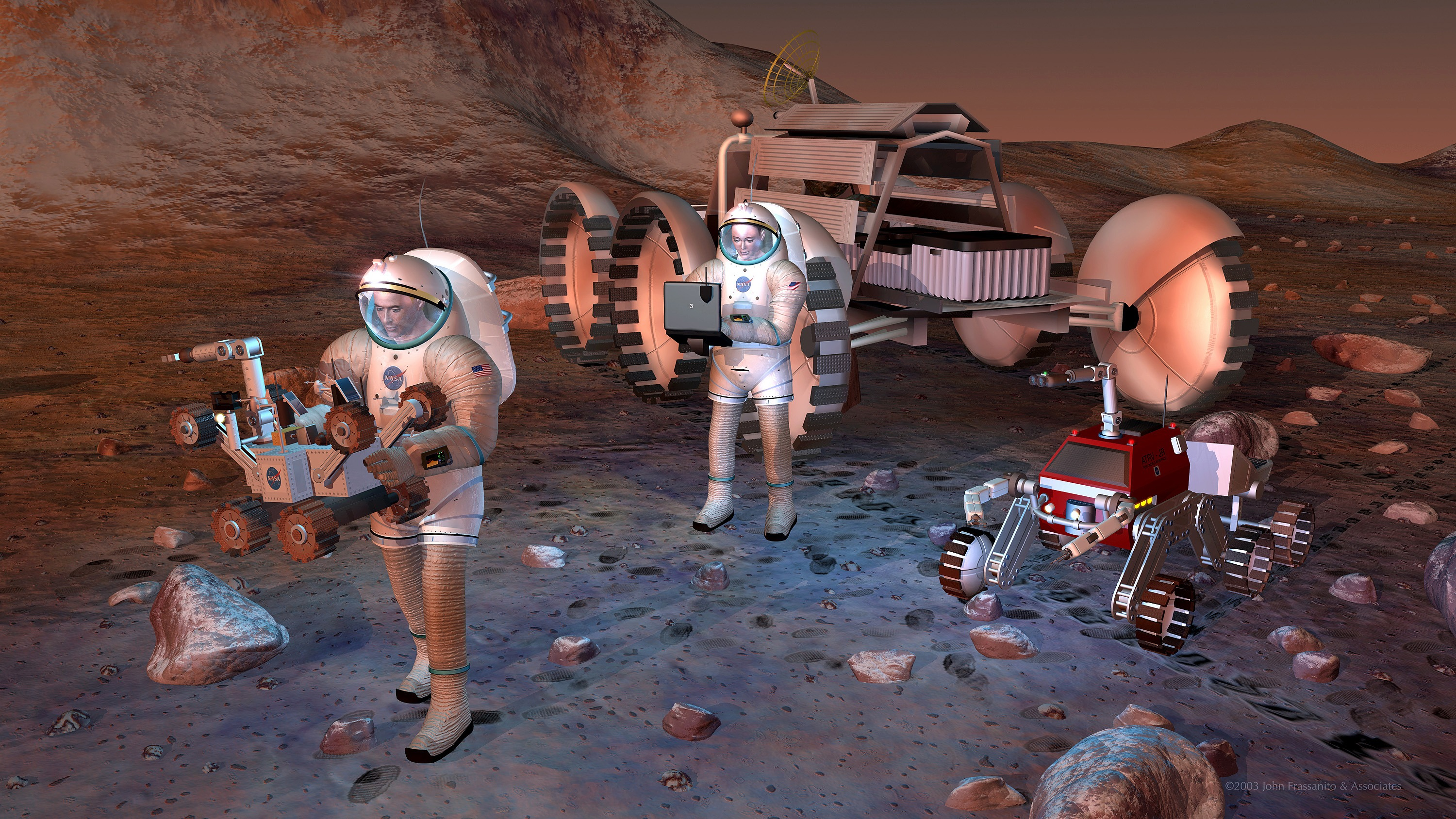
Artist's concept of future humans on Mars.
August 24, 2004
Credits
NASA/JPL-Caltech
ENLARGE
[51, 179]
Related
NASA’s Mars Odyssey orbiter captured the first-ever views of Mars that showcase the curving horizon and layers of atmosphere, similar to what an astronaut sees of Earth from the International Space...
Mars Report: What Would Mars Look Like if an Astronaut Could Orbit the Planet
This movie shows three views of the Martian moon Phobos as viewed in visible light by NASA's 2001 Mars Odyssey orbiter. The apparent motion is due to movement by Odyssey's infrared camera, Thermal ...
Odyssey's Three Views of Phobos in Visible Light
Re-analysis of 2002-2009 data from a hydrogen-finding instrument on NASA's Mars Odyssey orbiter increased the resolution of maps of hydrogen abundance.
Analysis Sharpens Mars Hydrogen Map, Hinting Equatorial Water Ice
The dunes and dust devil tracks in this VIS image are located on the plains of Planum Chronium.
Dunes and dust devil tracks in Planum Chronium
Echus Chasma forms the boundary between the Tharsis volcanoes to the west and Lunae Planum to the east. This region is one of both tectonically fractured rocks (top of image) and volcanic flows (mi...
Echus Chasma
This computer-generated view based on multiple orbital observations shows Mars' Gale crater as if seen from an aircraft north of the crater.
Oblique view of Gale Crater from the North
Fans and ribbons of dark sand dunes creep across the floor of Bunge Crater in response to winds blowing from the direction at the top of the picture.
Mars Odyssey All Stars: Bunge Crater Dunes
This image from NASA's 2001 Mars Odyssey spacecraft shows part of the caldera floor of Arsia Mons. Arsia Mons is the southernmost of the Tharsis volcanoes. It is 270 miles in diameter, almost 12 mi...
Investigating Mars: Arsia Mons
NASA Science missions circle Earth, the Sun, the Moon, Mars and many other destinations within our solar system, including spacecraft that look out even further into our universe. The Science Fleet...
SMD Spacecraft Fleet
Part of a multispectral THEMIS infrared image of Nili Patera caldera on Syrtis Major has been superimposed on a high-resolution THEMIS visual image.
Nili Patera and Dacite Lava Flow
Martian surface frost, made up largely of carbon dioxide, appears blueish-white in these images from the Thermal Emission Imaging System (THEMIS) camera aboard NASA’s 2001 Odyssey orbiter. THEMIS t...
Four Images of Morning Frost on Mars
NASA's NEOWISE mission detected comet C/2013 A1 Siding Spring on July 28, 2014, less than three months before this comet's close flyby of Mars on Oct. 19. This merging of multiple images presents t...
NEOWISE Spies Comet C/2013 A1 Siding Spring a Second Time
NASA is advancing the Journey to Mars by starting the conversation about where humans may one day land on the Red Planet.
Mars Exploration Zone Layout Considerations
This color-coded map indicates the depth to icy layers at a site in southern Mars. The dense, icy layer retains heat better than the looser soil above it, so where the icy layer is closer to the su...
Depth-to-Ice Map of a Southern Mars Site Near Melea Planum
A dust storm continues to envelop the Red Planet and Curiosity’s labs are back in action.
Mars Report: July 2018
A false-color mosaic focuses on one junction in Noctis Labyrinthus where canyons meet to form a depression 4,000 meters (13,000 feet) deep.
Mars Odyssey All Stars: Noctis Canyon
Mars Odyssey Project Manager Gaylon McSmith, of NASA's Jet Propulsion Laboratory
Mars Odyssey Project Manager Gaylon McSmith
This artist's concept shows NASA's Mars orbiters lining up behind the Red Planet for their "duck and cover" maneuver to shield them fro comet dust that may result from the close flyby of comet Sidi...
Siding Spring Mars Spacecraft
This mosaic of daytime infrared images of Gusev Crater, taken by the camera system on the Mars Odyssey spacecraft, has been draped over topography data obtained by Mars Global Surveyor.
Gusev Crater
This image is near the southern edge of a low, broad volcanic feature called Syrtis Major.
Syrtis Major
This image combines two products from the first pointing at the Martian moon Phobos by the THEMIS camera on NASA's Mars Odyssey orbiter, on Sept. 29, 2017. Surface-temperature information from obse...
Temperature Gradient on Martian Moon Phobos
Sand dunes shaped like blue-black flames lie next to a central hill within an unnamed, 120-kilometer-wide (75-mile-wide) crater in eastern Arabia on Mars.
Mars Odyssey All Stars: Arabia Dunes
The annotated area of Mars in this illustration holds near-surface water ice that would be easily accessible for astronauts to dig up. The water ice was identified as part of a map using data from ...
Water Ice Marked on Mars Globe
Mars is experiencing large regional dust storms over its northern hemisphere during the past week.
The Martian Dust Storm of June 2018
Download a PDF of the 2001 Mars Odyssey Launch Press Kit.
2001 Mars Odyssey Launch Press Kit
You Might Also Like
The agency is asking the NASA community to work together to develop a revised plan that leverages innovation and proven technology.
NASA Sets Path to Return Mars Samples, Seeks Innovative Designs
NASA has proven powered, controlled flight is possible on other worlds, just as the Wright brothers proved it was possible on Earth.
After Three Years on Mars, NASA's Ingenuity Helicopter Mission Ends
The agency established the board in May 2023 to evaluate the technical, cost, and schedule plans prior to confirmation of the mission’s design.
NASA Releases Independent Review's Mars Sample Return Report
A pair of quakes in 2021 sent seismic waves deep into the Red Planet’s core, giving scientists the best data yet on its size and composition.
NASA InSight Study Provides Clearest Look Ever at Martian Core
Ten sample tubes, capturing an amazing variety of Martian geology, have been deposited on Mars’ surface so they could be studied on Earth in the future.
NASA's Perseverance Rover Completes Mars Sample Depot
Filled with rock, the sample tube will be one of 10 forming a depot of tubes that could be considered for a journey to Earth by the Mars Sample Return campaign.
NASA's Perseverance Rover Deposits First Sample on Mars Surface