NASA
NASA Science
Mars Exploration Program
Skip Navigation
menu
Images
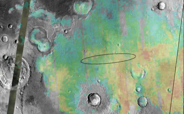
Meridiani Planum
August 24, 2004
Credits
NASA/JPL/Arizona State University
ENLARGE
[51, 179]
Related
Colors in this image of the Martian moon Phobos indicate a range of surface temperatures detected by observing the moon on Sept. 29, 2017, with the Thermal Emission Imaging System (THEMIS) camera o...
Martian Moon Phobos in Thermal Infrared Image
Seasons change even on Mars and NASA's fleet of explorers are helping scientists learn more about the effects on the Red Planet.
Mars Report: How's the Weather on Mars?
Sand dunes shaped like blue-black flames lie next to a central hill within an unnamed, 120-kilometer-wide (75-mile-wide) crater in eastern Arabia on Mars.
Mars Odyssey All Stars: Arabia Dunes
No NASA Mars orbiter has been in a position to observe morning daylight on Mars since the twin Viking orbiters of the 1970s.
Martian Morning Clouds Seen by Viking Orbiter 1 in 1976
NASA's Mars Odyssey spacecraft passes above a portion of the planet that is rotating into the sunlight in this artist's concept illustration. The spacecraft has been orbiting Mars since October ...
Odyssey over Martian Sunrise, 3-D (Artist Concept)
A large mound of sand and dune forms are located on the floor of an unnamed crater south of Rabe Crater in Noachis Terra.
Rabe Crater in Noachis Terra
Buzz Aldrin, an Apollo 11 astronaut who walked on the moon, makes a holographic appearance in 'Destination: Mars,' a mixed-reality tour of a part of Mars that NASA's Curiosity rover has explored.
Buzz Aldrin
NASA's Phoenix Mars Lander, its backshell and its heatshield are visible within this enhanced-color image of the Phoenix landing site taken on Jan. 6, 2010 by the High Resolution Imaging Science Ex...
Phoenix Lander Amid Disappearing Spring Ice
Snow falls and ice and frost form on Mars, too. NASA's spacecraft on and orbiting the Red Planet reveal the similarities to and differences from how we experience winter on Earth.
Mars Report: Winter Wonderland on Mars
Download a PDF of the 2001 Mars Odyssey Arrival Press Kit.
2001 Mars Odyssey Arrival Press Kit
NASA's 2001 Mars Odyssey orbiter arrived at Mars on Oct. 24, 2001.
Mars Odyssey Orbiter By the Numbers
Morning clouds fill Coprates Chasma on Mars in this Nov. 25, 2015, image from the THEMIS camera on NASA's Mars Odyssey. No orbiter systematically observed Mars in morning sunlight before 2015. The ...
Mars Odyssey View of Morning Clouds in Canyon
This movie begins with an animation (artist's rendering) of NASA's Mars Reconnaissance Orbiter spacecraft above Mars. The scene zooms into an "X-ray" view of the spacecraft, revealing the High Reso...
Mars Orbiter Observes Comet Siding Spring
This movie shows the Martian moon Phobos as viewed in visible light by NASA's 2001 Mars Odyssey orbiter on April 24, 2019. The apparent motion is due to movement by Odyssey's infrared camera, Therm...
Odyssey Views Phobos in Visible Light: April 24, 2019
Re-analysis of 2002-2009 data from a hydrogen-finding instrument on NASA's Mars Odyssey orbiter increased the resolution of maps of hydrogen abundance.
Analysis Sharpens Mars Hydrogen Map, Hinting Equatorial Water Ice
Download a PDF of the Mars as Art Booklet.
Mars as Art (2013)
Color coding in this map of a far-northern site on Mars indicates the change in nighttime ground-surface temperature between summer and fall. This site, like most of high-latitude Mars, has water i...
Depth-to-Ice Map of an Arctic Site on Mars
A new map of Mars' gravity made with three NASA spacecraft is the most detailed to date, providing a revealing glimpse into the hidden interior of the Red Planet. Satellites always orbit a planet's...
Mars Gravity Map
The artist's animation depicts how NASA's Curiosity rover will communicate with Earth during landing. As the rover descends to Mars, it will send out basic radio-frequency tones that go directly to...
Curiosity Speaks
Mars program Chief Engineer Robert Shotwell describes Mars Odyssey's unprecedented view of comet Siding Spring as the comet sweeps by the Red Planet on Oct. 19 and how it will maneuver to take images.
NASA's Mars Odyssey Maneuvers to Image Comet Siding Spring
Planum Boreum crater
Planum Boreum crater
This color-coded map indicates the depth to icy layers at a site in southern Mars. The dense, icy layer retains heat better than the looser soil above it, so where the icy layer is closer to the su...
Depth-to-Ice Map of a Southern Mars Site Near Melea Planum
This image of Phobos is one product of the first pointing at that Martian moon by the THEMIS camera on NASA's Mars Odyssey orbiter. The Sept. 29, 2017, observation also provided information about ...
Martian Moon Phobos Observed by NASA's Odyssey
A group of small, unnamed craters in the martian southern hemisphere is the first site captured by a group of middle school students who are operating the camera system onboard NASA's Mars Odyssey ...
Students participating in the Mars Student Imaging Project
Part of a multispectral THEMIS infrared image of Nili Patera caldera on Syrtis Major has been superimposed on a high-resolution THEMIS visual image.
Nili Patera and Dacite Lava Flow
You Might Also Like
The agency is asking the NASA community to work together to develop a revised plan that leverages innovation and proven technology.
NASA Sets Path to Return Mars Samples, Seeks Innovative Designs
NASA has proven powered, controlled flight is possible on other worlds, just as the Wright brothers proved it was possible on Earth.
After Three Years on Mars, NASA's Ingenuity Helicopter Mission Ends
The agency established the board in May 2023 to evaluate the technical, cost, and schedule plans prior to confirmation of the mission’s design.
NASA Releases Independent Review's Mars Sample Return Report
A pair of quakes in 2021 sent seismic waves deep into the Red Planet’s core, giving scientists the best data yet on its size and composition.
NASA InSight Study Provides Clearest Look Ever at Martian Core
Ten sample tubes, capturing an amazing variety of Martian geology, have been deposited on Mars’ surface so they could be studied on Earth in the future.
NASA's Perseverance Rover Completes Mars Sample Depot
Filled with rock, the sample tube will be one of 10 forming a depot of tubes that could be considered for a journey to Earth by the Mars Sample Return campaign.
NASA's Perseverance Rover Deposits First Sample on Mars Surface