NASA
NASA Science
Mars Exploration Program
Skip Navigation
menu
Images
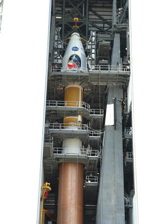
Countdown Nears: Final Tests
July 14, 2009
Credits
NASA
ENLARGE
[51, 178]
Related
Download a PDF of the Mars Reconnaissance Orbiter Launch Press Kit.
Mars Reconnaissance Orbiter Launch Press Kit
Dry ice causes "Swiss Cheese" terrain on Mars.
"Swiss Cheese" Terrain on Mars
This image, taken with the High Resolution Imaging Science Experiment (HiRISE) camera, shows the transition between the "Murray Formation," in which layers are poorly expressed and difficult to tra...
Geological Transition
This HiRISE image shows erosional features formed by seasonal frost near the south pole of Mars.
Erosion Features near the South Pole of Mars
This map shows the footprints of images taken by the HiRISE camera on NASA's Mars Reconnaissance Orbiter as part of advance analysis of the area where NASA's InSight mission will land in 2018. The ...
Advance Inspection of NASA's Next Mars Landing Site
The total distance driven by NASA's Mars rover Curiosity passed the one-mile mark a few days before the first anniversary of the rover's landing on Mars.
Full Curiosity Traverse Passes One-Mile Mark
Martian gullies as seen in the top image from HiRISE on NASA's Mars Reconnaissance Orbiter resemble gullies on Earth that are carved by liquid water. However, when they are observed with the additi...
Adding Composition Data About Mars Gullies
This artist's concept shows NASA's Mars orbiters lining up behind the Red Planet for their "duck and cover" maneuver to shield them fro comet dust that may result from the close flyby of comet Sidi...
Siding Spring Mars Spacecraft
Back-and-forth blinking of this two-image animation shows movement of a sand dune on Mars. The images are part of a study published by Nature on May 9, 2012, reporting movement of Martian sand dune...
Advancing Dune in Nili Patera, Mars
These two frames were taken of the same place on Mars by the same camera before (left) and after some images from the camera began showing unexpected blur. The images are from the HiRISE camera on ...
Slight Blurring in Newer Image from Mars Orbiter
NASA's InSight spacecraft and its recently deployed Wind and Thermal Shield were imaged on Feb. 4 by the HiRISE camera aboard NASA's Mars Reconnaissance Orbiter.
InSight Seismometer's Wind and Thermal Shield Seen from Space
The Mars Color Imager test view looks northward and includes the large Argyre Basin in Mars' southern hemisphere.
View of Argyre Basin from Test of Mars Color Image
This image includes an especially long example of a type of dark marking that advances down some Martian slopes in warmer months and fades away in cooler months.
Long, Recurring Linear Marking on Martian Slope
Stokes Crater, pictured here, is one of at least nine craters in the northern lowlands of Mars with exposures of hydrated minerals detected from orbit, according to a June 25, 2010, report.
Hydrated Minerals Exposed at Stokes, Northern Mars
This image from the HiRISE camera on NASA's Mars Reconnaissance Orbiter shows a location associated with the novel and movie, "The Martian." It is the tale's planned landing site for the Ares 4 mis...
'The Martian' Story's Ares 4 Landing Site
Phobos from 5,800 Kilometers
Phobos from 6,800 Kilometers
This image shows part of Ladon Vallis that is located within Ladon basin.
Light-Toned Layered Rock Outcrop in Ladon Valles (3-D)
Candor Chasma is one of the major canyons within Valles Marineris. The floor of this canyon consist of many layers of light-toned sediments that have been folded and faulted, giving them the wavy a...
Western Candor (3-D)
This graphic depicts the Mars Climate Sounder instrument on NASA's Mars Reconnaissance Orbiter measuring the temperature of a cross section of the Martian atmosphere as the orbiter passes above the...
Scanning Martian Atmospheric Temperatures
This rainbow-colored map shows underground water ice on Mars. Cool colors are closer to the surface than warm colors; black zones indicate areas where a spacecraft would sink into fine dust; the ou...
A Water Ice Map for Mars
The bright linear features cutting the bedrock in the center region of this image look like mineral veins.
Mineral Veins (3-D)
Impact cratering and erosion combine to reveal the composition of the Martian underground by exposing materials from the subsurface.
Clay Minerals in Craters and Escarpments on Mars (Figure 1)
Follow along on a tour of the landing scene of NASA's Curiosity rover in this video made up of images from two NASA orbiters. The movie begins with a global image from NASA's Mars Global Surveyor, ...
Zooming in on the Scene of Curiosity's Landing
This sequence of images shows a blast zone where the sky crane from NASA's Curiosity rover mission hit the ground after setting the rover down in August 2012, and how that dark scar's appearance ch...
Changes in Scars From 2012 Mars Landing
This image from NASA's Mars Reconnaissance Orbiter (MRO) shows the western wall of a small pit that is located along the floor of a larger trough in Coprates Catena. Dark layers line the bottom; li...
Layers along a Pit in Coprates Catena
You Might Also Like
The agency is asking the NASA community to work together to develop a revised plan that leverages innovation and proven technology.
NASA Sets Path to Return Mars Samples, Seeks Innovative Designs
NASA has proven powered, controlled flight is possible on other worlds, just as the Wright brothers proved it was possible on Earth.
After Three Years on Mars, NASA's Ingenuity Helicopter Mission Ends
The agency established the board in May 2023 to evaluate the technical, cost, and schedule plans prior to confirmation of the mission’s design.
NASA Releases Independent Review's Mars Sample Return Report
A pair of quakes in 2021 sent seismic waves deep into the Red Planet’s core, giving scientists the best data yet on its size and composition.
NASA InSight Study Provides Clearest Look Ever at Martian Core
Ten sample tubes, capturing an amazing variety of Martian geology, have been deposited on Mars’ surface so they could be studied on Earth in the future.
NASA's Perseverance Rover Completes Mars Sample Depot
Filled with rock, the sample tube will be one of 10 forming a depot of tubes that could be considered for a journey to Earth by the Mars Sample Return campaign.
NASA's Perseverance Rover Deposits First Sample on Mars Surface