NASA
NASA Science
Mars Exploration Program
Skip Navigation
menu
Images
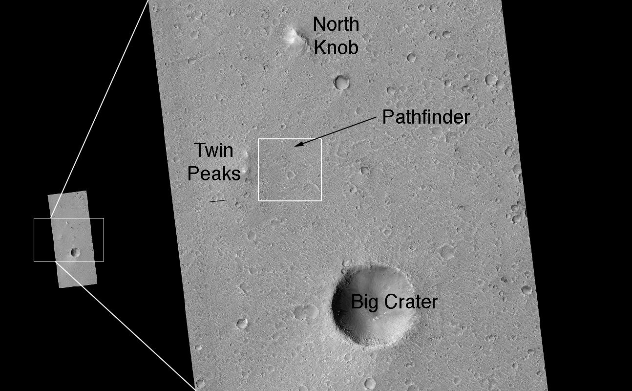
Landing Site Region
January 11, 2007
Credits
NASA/JPL/Univ. of Arizona
ENLARGE
[51, 178]
Related
Amazingly, this HiRISE image has captured at least four avalanches, or debris falls, in action.
Caught in Action: Avalanches on North Polar Scarps
This mosaic, taken with the High Resolution Imaging Science Experiment (HiRISE) camera on NASA's Mars Reconnaissance Orbiter, shows the planned route (in yellow) of NASA's Curiosity rover from "Pah...
Curiosity Rover Planned Route
A towering dust devil, casts a serpentine shadow over the Martian surface in this image acquired by the High Resolution Imaging Science Experiment (HiRISE) camera on NASA's Mars Reconnaissance Orbi...
The Serpent Dust Devil of Mars
The bright landing platform left behind by NASA's Mars Exploration Rover Opportunity in 2004 is visible inside Eagle Crater, where "Opportunity Lander" is indicated in this annotated, April 8, 2...
Rover's Landing Hardware at Eagle Crater, Mars (Annotated)
Mars Reconnaissance Orbiter Project Manager Jim Graf hugs Jet Propulsion Laboratory Director Dr. Charles Elachi after a successful orbit insertion on March 10, 2006.
Mars Reconnaissance Orbiter Mission Team Members Celebrate Orbit Insertion Success
This set of images shows "before" and "after" images of NASA's Phoenix Mars Lander taken by the High Resolution Imaging Science Experiment (HiRISE) camera on NASA's Mars Reconnaissance Orbiter.
Image from Mars Orbit Indicates Solar Panels on Phoneix Lander may have Collapsed
This animation demonstrates the salty ponds and streams that scientists think may have been left behind as Gale Crater dried out over time. The bottom of the image is the floor of Gale Crater, with...
Sutton Island Model of Drying Lakes
This scene shows dark sand dunes marching over the ridges created by an alluvial (water-deposited) fan in an impact crater.
Dunes on Ridges
The enhanced-color subimage shows a great variety of colors and textures in the bedrock, where it is exposed from beneath a dark fine-grained mantle. The mantle is sometimes modified by the wind in...
Uplifted Jumble of Ancient Bedrock (3-D)
The MRO Context Camera, CTX, at Malin Space Science Systems in 2004, before it was delivered and mounted on the spacecraft.
Context Camera for Mars Reconnaissance Orbiter
This movie begins with an animation (artist's rendering) of NASA's Mars Reconnaissance Orbiter spacecraft above Mars. The scene zooms into an "X-ray" view of the spacecraft, revealing the High Reso...
Mars Orbiter Observes Comet Siding Spring
This image acquired on December 9, 2018 by NASAs Mars Reconnaissance Orbiter, shows Athabasca Valles with lava flows originating from Elysium Mons to the northwest.
Almost Like Water
From a distance, the floor of this crater looks like a giant honeycomb or spider web. The intersecting shapes, or polygons, commonly occur in the northern lowlands of Mars.
Polygonal Patterned Ground
This enhanced-color image shows sand dunes trapped in an impact crater in Noachis Terra, Mars.
Dunes in Noachis Terra Region of Mars
This annotated image shows where features seen in an observation by NASA's Mars Reconnaissance Orbiter have been interpreted as hardware from the Dec. 25, 2003, arrival at Mars of the United Kingdo...
Components of Beagle 2 Flight System on Mars
NASA's Mars Reconnaissance Orbiter observes many slopes in the middle latitudes of Mars showing icy flows or glaciers. The region shown here, in the south-facing slope of a crater, is unusual becau...
Go with the (Bright) Flow
This comparison of before-and-after images shows two spots that likely appeared in connection with the Oct. 19, 2016, Mars arrival of the European Space Agency's Schiaparelli test lander. The image...
Signs of Schiaparelli Test Lander Seen From Orbit
This series of images from NASA's Mars Reconnaissance Orbiter successively zooms into "spider" features -- or channels carved in the surface in radial patterns -- in the south polar region of Mars.
Volunteers Help Decide Where to Point Mars Camera
Follow along on a tour of the landing scene of NASA's Curiosity rover in this video made up of images from two NASA orbiters. The movie begins with a global image from NASA's Mars Global Surveyor, ...
Zooming in on the Scene of Curiosity's Landing
Mawrth Vallis contains clay minerals that formed by chemical alteration of rocks by water. The central part of the image is dominated by light-toned materials with curving fractures of many differe...
Mawrth Vallis Closeup (3-D)
A comparison of two radargrams from the SHARAD instrument on NASA's Mars Reconnaissance Orbiter shows effects on the Martian ionosphere from the close passage of a comet.
Radar Indication of Effect of Comet Flyby on Martian Ionosphere
This pair of before (left) and after (right) images from the High Resolution Imaging Science Experiment (HiRISE) camera on NASA's Mars Reconnaissance Orbiter documents formation of a new channel on...
A New Gully Channel in Terra Sirenum, Mars
This close-up image of a dust storm on Mars was acquired by the Mars Color Imager instrument on NASA's Mars Reconnaissance Orbiter on Nov. 7, 2007.
Martian Dust Storm
This HiRISE image shows a crater approximately 11 km (7 miles) in diameter, located in Acidalia Planitia, part of the Northern Plains. Several features in and around this crater are suggestive of f...
Signs of Fluids and Ice in Acidalia Planitia
A view from NASA's Mars Reconnaissance Orbiter on April 8, 2015, catches sight of NASA's Curiosity Mars rover passing through a valley called "Artist's Drive" on the lower slope of Mount Sharp.
Mars Orbiter Sees Curiosity Rover in 'Artist's Drive'
You Might Also Like
The agency is asking the NASA community to work together to develop a revised plan that leverages innovation and proven technology.
NASA Sets Path to Return Mars Samples, Seeks Innovative Designs
NASA has proven powered, controlled flight is possible on other worlds, just as the Wright brothers proved it was possible on Earth.
After Three Years on Mars, NASA's Ingenuity Helicopter Mission Ends
The agency established the board in May 2023 to evaluate the technical, cost, and schedule plans prior to confirmation of the mission’s design.
NASA Releases Independent Review's Mars Sample Return Report
A pair of quakes in 2021 sent seismic waves deep into the Red Planet’s core, giving scientists the best data yet on its size and composition.
NASA InSight Study Provides Clearest Look Ever at Martian Core
Ten sample tubes, capturing an amazing variety of Martian geology, have been deposited on Mars’ surface so they could be studied on Earth in the future.
NASA's Perseverance Rover Completes Mars Sample Depot
Filled with rock, the sample tube will be one of 10 forming a depot of tubes that could be considered for a journey to Earth by the Mars Sample Return campaign.
NASA's Perseverance Rover Deposits First Sample on Mars Surface