NASA
NASA Science
Mars Exploration Program
Skip Navigation
menu
Images
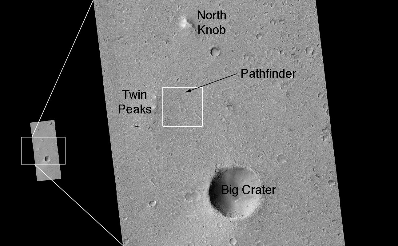
Landing Site Region
January 11, 2007
Credits
NASA/JPL/Univ. of Arizona
ENLARGE
[51, 178]
Related
This series of images shows warm-season features that might be evidence of salty liquid water active on Mars today.
Dark Flows in Newton Crater Extending During Summer (Six-Image Sequence)
This vertically exaggerated view shows scalloped depressions in a part of Mars where such textures prompted researchers to check for buried ice, using ground-penetrating radar aboard NASA's Mars Re...
Scalloped Terrain Led to Finding of Buried Ice on Mars
This image shows the location of the rover-containing section of new color image in relation to Solander Point.
Location of Opportunity at Solander Point
This image from the NASA Mars Reconnaissance Orbiter shows an impact scar on Mars made by pieces of the NASA Mars Science Laboratory spacecraft that the spacecraft shed just before entering the Mar...
Impact Scars from MSL Cruise Stage and Two Balance Weights (Figure 1)
These collapse pits probably formed when lava erupted from the side of Arsia Mons, draining underground magma reservoirs. The resulting voids collapse due to the weight of the solid lava above them...
Pits on Arsia Mons (3-D)
This image includes an especially long example of a type of dark marking that advances down some Martian slopes in warmer months and fades away in cooler months.
Long, Recurring Linear Marking on Martian Slope
This HiRISE image covers the southwest portion of the terraces and floor of Holden Crater situated in southwest Margaritifer Terra.
Holden Crater Megabreccia: A Telltale Sign of a Sudden and Violent Event
This map shows the route driven by NASA's Mars rover Curiosity through the 43rd Martian day, or sol, of the rover's mission on Mars (Sept. 19, 2012).
Curiosity Traverse Map Through Sol 43
HiRISE captured this image of an eroded mesa made famous by its similarity to a human face in a Viking Orbiter image with much lower spatial resolution and a different lighting geometry.
Popular Landform in Cydonia Region
The bright linear features cutting the bedrock in the center region of this image look like mineral veins.
Mineral Veins (3-D)
This image from NASA's Mars Reconnaissance Rover shows the edge of a mound of ice in one of the mid-latitude craters. Scientists now realize that ice is very common on the Martian surface.
Icy Layers in Craters
This image acquired on January 20, 2019 by NASAs Mars Reconnaissance Orbiter, shows a chaotic jumble of bright layered sediments, perhaps resulting from large landslides.
Jumbled Blocks on the Floor of Melas Chasma
This image acquired on March 29, 2011 by NASAs Mars Reconnaissance Orbiter, shows dunes with ripples on their upwind slopes and dark streaks on their downwind slopes.
Active Dunes in Wirtz Crater
This image, taken with the High Resolution Imaging Science Experiment (HiRISE) camera, shows a mesa within the "Murray Buttes" area on Mars showing a complex fracture pattern (black arrow) protrudi...
'Murray Buttes' Mesa
Explanation on how CRISM hyperspectral images are used to understand the history and formation of Valles Marineris, one of the largest canyons in the solar system, and how the data is used to unrav...
CRISM: Exploring the Geology of Mars
This March 20, 2014, image from the MARCI camera on NASA's Mars Reconnaissance Orbiter has a dark spot (at center of inscribed rectangle) noticed while the image was being examined for a weather re...
Impact Scar Detected in Mars Weathercam Image
HiRISE image of Planum Chronium Region.
Planum Chronium Region
This feature has a strange appearance, as if the crater has feet with toes sticking out of two sides. Let's try to explain this.
Weird Crater
This map shows the route driven by NASA's Curiosity Mars rover from the location where it landed in August 2012 to its location in December 2016, which is in the upper half of a geological unit cal...
Late 2016 Map of NASA's Curiosity Mars Rover Mission
Polygons are of great interest because they often indicate the presence of shallow ice or of desiccation such as in a mud flat. However, nature sometimes seems too clever for us.
Polygonal Sand Dunes
The Electris region of Mars contains some interesting features, such as the raised-relief blocks of material visible in this image.
Remnant of Unconformable Deposit in Electris (3-D)
This image from NASA's Mars Reconnaissance Orbiter shows a hill with a central crater. Such features have been interpreted as both mud volcanoes (really a sedimentary structure) and as actual volca...
A Volcano of Mud or Lava?
Why does HiRISE take so many repeat images of the same area? Repeat coverage actually serves a special purpose, such as detecting seasonal changes (frost deposition and sublimation) and temporal ch...
Frost on Crater Slope
On Nov. 1, 2016, the HiRISE camera on NASA's Mars Reconnaissance Orbiter observed the impact site of Europe's Schiaparelli test lander, gaining the first color view of the site since the lander's O...
Schiaparelli Impact Site on Mars, in Color
This map shows the thickness of the north polar layered deposits on Mars as measured by the Shallow Radar instrument on NASA's Mars Reconnaissance Orbiter.
How Thick is the North Polar Ice Cap on Mars?
You Might Also Like
The agency is asking the NASA community to work together to develop a revised plan that leverages innovation and proven technology.
NASA Sets Path to Return Mars Samples, Seeks Innovative Designs
NASA has proven powered, controlled flight is possible on other worlds, just as the Wright brothers proved it was possible on Earth.
After Three Years on Mars, NASA's Ingenuity Helicopter Mission Ends
The agency established the board in May 2023 to evaluate the technical, cost, and schedule plans prior to confirmation of the mission’s design.
NASA Releases Independent Review's Mars Sample Return Report
A pair of quakes in 2021 sent seismic waves deep into the Red Planet’s core, giving scientists the best data yet on its size and composition.
NASA InSight Study Provides Clearest Look Ever at Martian Core
Ten sample tubes, capturing an amazing variety of Martian geology, have been deposited on Mars’ surface so they could be studied on Earth in the future.
NASA's Perseverance Rover Completes Mars Sample Depot
Filled with rock, the sample tube will be one of 10 forming a depot of tubes that could be considered for a journey to Earth by the Mars Sample Return campaign.
NASA's Perseverance Rover Deposits First Sample on Mars Surface