NASA
NASA Science
Mars Exploration Program
Skip Navigation
menu
Mars Now
Mars Now
View the current location and spacecraft communications activity of operating landers, rovers and orbiters using the NASA’s Mars Relay Network.
GO
Mars Now
View a 3D visualization of all the missions exploring the Red Planet
The Red Planet
Dashboard
Science Goals
The Planet
Atmosphere
Astrobiology
Past, Present, Future, Timeline
Dashboard
Science Goals
The Planet
Atmosphere
Astrobiology
Past, Present, Future, Timeline
The Program
Mission Statement
About the Program
Organization
Why Mars?
Research Programs
Planetary Resources
Technologies
Mission Statement
About the Program
Organization
Why Mars?
Research Programs
Planetary Resources
Technologies
News & Events
News
Events
News
Events
Multimedia
Images
Videos
Audio
Podcasts
More Resources
Images
Videos
Audio
Podcasts
More Resources
Missions
Past
Present
Future
International Partners
Past
Present
Future
International Partners
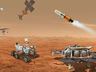
Active & Future Missions
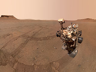
A mission to investigate key questions about potential life on Mars.
Mars 2020 Perseverance Rover
The largest and most capable rover ever sent to Mars.
Curiosity Rover
Measures Mars' atmosphere to understand its climate change.
MAVEN
Takes high-resolution imagery of Martian terrain with extraordinary clarity.
Mars Reconnaissance Orbiter
NASA's longest-lasting spacecraft at Mars.
2001 Mars Odyssey
Multi-mission campaign to bring Mars samples safely back to Earth.
Mars Sample Return
All Missions
International Partners
More
Images
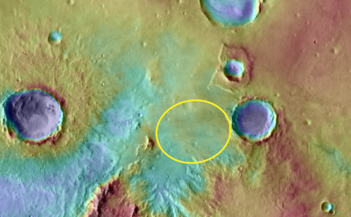
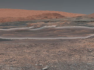
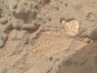
Southern Meridiani
February 15, 2009
Southern Meridiani
Credits
NASA/JPL-Caltech
ENLARGE
[51, 176]
Related
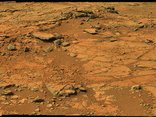
From a position in the shallow "Yellowknife Bay" depression, NASA's Mars rover Curiosity used its right Mast Camera (Mastcam) to take the telephoto images combined into this panorama of geological ...
View from Inside 'Yellowknife Bay' (Raw-color)
This image of the northwestern portion of Mars' Gale Crater and terrain north of it, from the European Space Agency's Mars Express orbiter, provides a locator map for some features visible in an Oc...
Locator Map for Features in Curiosity Panorama
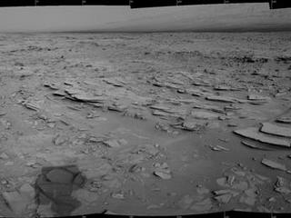
The NASA Mars rover Curiosity used its Navigation Camera (Navcam) during the mission's 120th Martian day, or sol (Dec. 7, 2012), to record the seven images combined into this panoramic view.
Sol 120 Panorama from Curiosity, near 'Shaler'
Technicians, at the Payload Hazardous Servicing Facility at NASA's Kennedy Space Center in Florida, use an overhead crane to move a rocket-powered descent stage for integration with NASA's Mars Sci...
Descent Stage
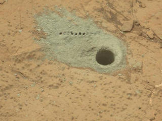
The Chemistry and Camera (ChemCam) instrument on NASA's Mars rover Curiosity was used to check the composition of gray tailings from the hole in rock target "Cumberland" that the rover drilled on M...
Drilled Hole and ChemCam Marks at 'Cumberland'
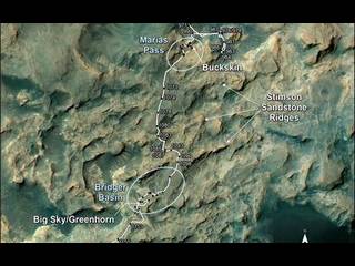
This map shows the route on lower Mount Sharp that NASA's Curiosity followed between April 19, 2015, and Nov. 5, 2015. During this period the mission investigated silica-rich rock targets includin...
Curiosity's Path During 2015 Studies of Silica-Rich Rocks
On Sol 84 (Oct. 31, 2012), NASA's Curiosity rover used the Mars Hand Lens Imager (MAHLI) to capture this set of 55 high-resolution images, which were stitched together to create this full-color sel...
High-Resolution Self-Portrait by Curiosity Rover Arm Camera
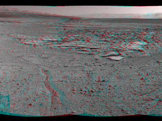
NASA's Curiosity Mars rover recorded this stereo view of various rock types at waypoint called "the Kimberley" shortly after arriving at the location on April 2, 2014. The scene appears three dimen...
Curiosity's View From Arrival Point at 'The Kimberley' Waypoint (Stereo)
Richard Cook has twice held the position of project manager of NASA's Mars Science Laboratory project at NASA's Jet Propulsion Laboratory, Pasadena, Calif.
Richard Cook
Curiosity’s twin, Scarecrow, gets down and dirty out in the Dumont Dunes in California’s Mojave Desert, near Death Valley.
Sandy Dunes
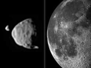
This illustration provides a comparison for how big the moons of Mars appear to be, as seen from the surface of Mars, in relation to the size that Earth's moon appears to be when seen from the surf...
Illustration Comparing Apparent Sizes of Moons
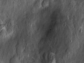
This close-up view shows NASA's Curiosity rover on the surface of Mars. The image was captured by the High-Resolution Imaging Science Experiment (HiRISE) camera on NASA's Mars Reconnaissance Orbite...
Curiosity Spotted!
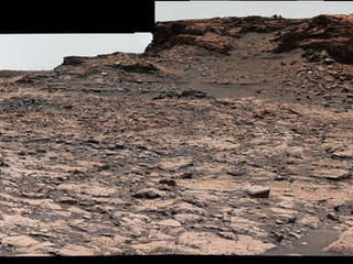
This panorama from the Mast Camera (Mastcam) of NASA's Curiosity Mars rover shows details of "Vera Rubin Ridge," which stretches about 4 miles (6.5 kilometers), end-to-end, on the northwestern flan...
Wide 'Vera Rubin Ridge' Ahead of Curiosity Mars Rover
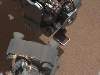
This image from the right Mast Camera (Mastcam) of NASA's Mars rover Curiosity shows a scoop full of sand and dust lifted by the rover's first use of the scoop on its robotic arm.
View of Curiosity's First Scoop Also Shows Bright Object
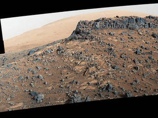
The mesa in the center of this scene from the "Murray Buttes" area on Mars is longer than a football field. The panorama combines images taken by the Mastcam on NASA's Curiosity Mars rover on Aug. ...
Cluster of Martian Mesas on Lower Mount Sharp, Sols 1438 and 1439
This view from the Mast Camera (Mastcam) on NASA's Curiosity Mars rover shows a site with a network of prominent mineral veins below a cap rock ridge on lower Mount Sharp.
Veiny 'Garden City' Site and Surroundings on Mount Sharp, Mars
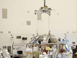
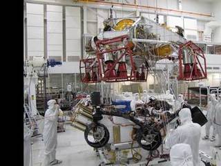
Spacecraft specialists test the descent stage and rover of the Mars Science Laboratory in this scene from the Spacecraft Assembly Facility at NASA's Jet Propulsion Laboratory, Pasadena, Calif.
Testing for Mars Science Laboratory Descent
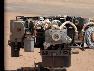
This image shows the Alpha Particle X-Ray Spectrometer (APXS) on NASA's Curiosity rover, with the Martian landscape in the background.
Portrait of APXS on Mars
This picture features some of the women working on the Curiosity rover, taken in the "Mars Yard," a simulated martian landscape right here at JPL.
Meet Many of the Women of Mars!
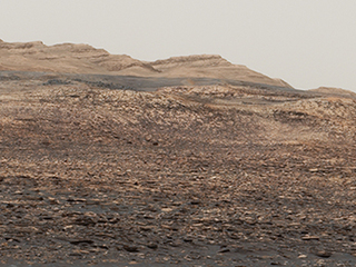
This mosaic taken by NASA's Mars Curiosity rover looks uphill at Mount Sharp, which Curiosity has been climbing.
Curiosity is Ready for Clay (Highlighted)
Where were you when Curiosity landed?
Where Were You When Curiosity Landed
This is the first 360-degree panorama in color of the Gale Crater landing site taken by NASA's Curiosity rover. The panorama was made from thumbnail versions of images taken by the Mast Camera.
Gale Crater Vista, in Glorious Color
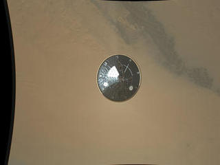
This color full-resolution image showing the heat shield of NASA's Curiosity rover was obtained during descent to the surface of Mars on Aug. 5 PDT (Aug. 6 EDT).
Curiosity's Heat Shield in Detail
NASA's Curiosity rover finds calcium deposits on Mars similar to those seen on Earth when water circulates in cracks and rock fractures.
Curiosity Finds Calcium-Rich Deposits
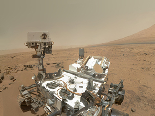
NASA's Perseverance rover has been on the surface of Mars since February of 2021, joining NASA's Curiosity rover, which has been studying the Red Planet since 2012.
Mars Report: Update on NASA's Perseverance Rover & Curiosity Rover (May 20, 2021)
From a position in the shallow "Yellowknife Bay" depression, NASA's Mars rover Curiosity used its right Mast Camera (Mastcam) to take the telephoto images combined into this panorama of geological ...
View from Inside 'Yellowknife Bay' (Raw-color)
This image of the northwestern portion of Mars' Gale Crater and terrain north of it, from the European Space Agency's Mars Express orbiter, provides a locator map for some features visible in an Oc...
Locator Map for Features in Curiosity Panorama
The NASA Mars rover Curiosity used its Navigation Camera (Navcam) during the mission's 120th Martian day, or sol (Dec. 7, 2012), to record the seven images combined into this panoramic view.
Sol 120 Panorama from Curiosity, near 'Shaler'
Technicians, at the Payload Hazardous Servicing Facility at NASA's Kennedy Space Center in Florida, use an overhead crane to move a rocket-powered descent stage for integration with NASA's Mars Sci...
Descent Stage
The Chemistry and Camera (ChemCam) instrument on NASA's Mars rover Curiosity was used to check the composition of gray tailings from the hole in rock target "Cumberland" that the rover drilled on M...
Drilled Hole and ChemCam Marks at 'Cumberland'
This map shows the route on lower Mount Sharp that NASA's Curiosity followed between April 19, 2015, and Nov. 5, 2015. During this period the mission investigated silica-rich rock targets includin...
Curiosity's Path During 2015 Studies of Silica-Rich Rocks
On Sol 84 (Oct. 31, 2012), NASA's Curiosity rover used the Mars Hand Lens Imager (MAHLI) to capture this set of 55 high-resolution images, which were stitched together to create this full-color sel...
High-Resolution Self-Portrait by Curiosity Rover Arm Camera
NASA's Curiosity Mars rover recorded this stereo view of various rock types at waypoint called "the Kimberley" shortly after arriving at the location on April 2, 2014. The scene appears three dimen...
Curiosity's View From Arrival Point at 'The Kimberley' Waypoint (Stereo)
Previous
Next
You Might Also Like
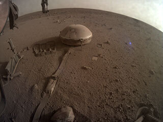
A pair of quakes in 2021 sent seismic waves deep into the Red Planet’s core, giving scientists the best data yet on its size and composition.
NASA InSight Study Provides Clearest Look Ever at Martian Core
Ten sample tubes, capturing an amazing variety of Martian geology, have been deposited on Mars’ surface so they could be studied on Earth in the future.
NASA's Perseverance Rover Completes Mars Sample Depot
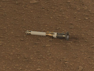
Filled with rock, the sample tube will be one of 10 forming a depot of tubes that could be considered for a journey to Earth by the Mars Sample Return campaign.
NASA's Perseverance Rover Deposits First Sample on Mars Surface
The agency is asking the NASA community to work together to develop a revised plan that leverages innovation and proven technology.
NASA Sets Path to Return Mars Samples, Seeks Innovative Designs
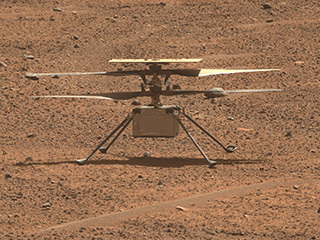
NASA has proven powered, controlled flight is possible on other worlds, just as the Wright brothers proved it was possible on Earth.
After Three Years on Mars, NASA's Ingenuity Helicopter Mission Ends
The agency established the board in May 2023 to evaluate the technical, cost, and schedule plans prior to confirmation of the mission’s design.
NASA Releases Independent Review's Mars Sample Return Report
A pair of quakes in 2021 sent seismic waves deep into the Red Planet’s core, giving scientists the best data yet on its size and composition.
NASA InSight Study Provides Clearest Look Ever at Martian Core
Ten sample tubes, capturing an amazing variety of Martian geology, have been deposited on Mars’ surface so they could be studied on Earth in the future.
NASA's Perseverance Rover Completes Mars Sample Depot
Filled with rock, the sample tube will be one of 10 forming a depot of tubes that could be considered for a journey to Earth by the Mars Sample Return campaign.
NASA's Perseverance Rover Deposits First Sample on Mars Surface
The agency is asking the NASA community to work together to develop a revised plan that leverages innovation and proven technology.
NASA Sets Path to Return Mars Samples, Seeks Innovative Designs
NASA has proven powered, controlled flight is possible on other worlds, just as the Wright brothers proved it was possible on Earth.
After Three Years on Mars, NASA's Ingenuity Helicopter Mission Ends
The agency established the board in May 2023 to evaluate the technical, cost, and schedule plans prior to confirmation of the mission’s design.
NASA Releases Independent Review's Mars Sample Return Report
Previous
Next