NASA
NASA Science
Mars Exploration Program
Skip Navigation
menu
Images
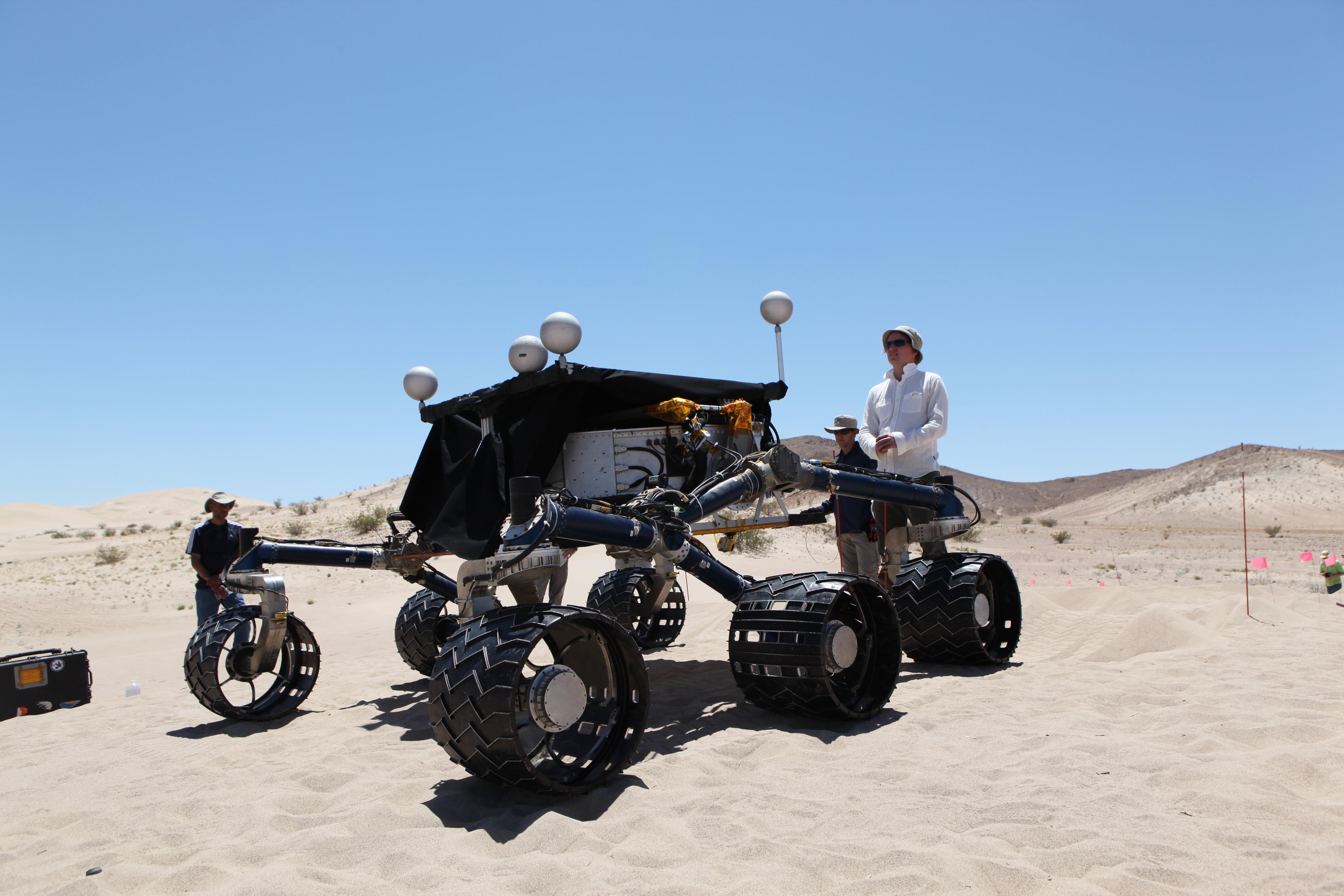
Curiosity's Stunt Double
June 05, 2014
Credits
NASA/JPL-Caltech
ENLARGE
[51, 176]
Related
This early-morning view from the Mastcam on NASA's Curiosity Mars rover on March 16, 2016, covers a portion of the inner wall of Gale Crater. At right, the image fades into glare of the rising sun....
Northern Portion of Gale Crater Rim Viewed from 'Naukluft Plateau'
This graphic shows tenfold spiking in the abundance of methane in the Martian atmosphere surrounding NASA's Curiosity Mars rover, as detected by a series of measurements made with the Tunable Laser...
Methane Measurements by NASA's Curiosity in Mars' Gale Crater
This is an artist's concept of the rover and descent stage for NASA's Mars Science Laboratory spacecraft during the final minute before the rover, Curiosity, touches down on the surface of Mars.
Curiosity and Descent Stage, Artist's Concept
The first demonstration of NASA's MAVEN Mars orbiter's capability to relay data from a Mars surface mission, on Nov. 6, 2014, included this and other images from NASA's Curiosity Mars rover. The im...
Image Relayed by MAVEN from Curiosity Mars Rover
This image is the first high-resolution color mosaic from NASA's Curiosity rover, showing the geological environment around the rover's landing site in Gale Crater on Mars.
First High-Resolution Color Mosaic of Curiosity's Mastcam Images (Raw-colors)
Unlike previous rovers sent to Mars, Curiosity is a robot chemist seeking evidence of past habitability on Mars.
The Science of Curiosity: Seeking Signs of Past Mars Habitability
These before-and-after images show the effects of weights from the entry vehicle of NASA's Curiosity rover hitting the surface of Mars.
Ballasts Hitting the Surface, Close-Up
This graphic from NASA's Curiosity mission shows an analysis of the composition of two rocks called "Crest" and "Rapitan" in the "Yellowknife Bay" area of Mars.
Signs of Hydrated Calcium Sulfates in Martian Rocks
This Mars Descent Imager (MARDI) camera will fly on the Curiosity rover of NASA's Mars Science Laboratory mission.
Mars Descent Imager for Curiosity
This nearly global mosaic of observations made by the Mars Color Imager on NASA's Mars Reconnaissance Orbiter on Nov. 18, 2012, shows a dust storm in Mars' southern hemisphere.
Martian Dust Storm, Nov. 18, 2012
The first examinations of Martian soil by the Sample Analysis at Mars, or SAM, instrument on NASA's Mars Curiosity rover show no definitive detection of Martian organic molecules at this point.
Chlorinated Compounds at 'Rocknest'
This video of thumbnail images from the Mars Descent Imager (MARDI) on NASA's Curiosity rover shows the heat shield dropping away from the rover on Aug. 5 PDT (Aug. 6 EDT). It covers the first 25 s...
Curiosity Bids Goodbye to Heat Shield
This Dec. 17, 2015, view combines multiple images from the telephoto-lens camera of the Mast Camera (Mastcam) on NASA's Curiosity Mars rover to reveal fine details of the downwind face of "Namib Du...
Mastcam Telephoto of a Martian Dune's Downwind Face
The route NASA’s Curiosity Mars rover has taken while driving through the lower part of Mount Sharp is shown as a pale line here. Different parts of the mountain are labeled by color; Curiosity is ...
Curiosity's Path to Gediz Vallis Ridge and Beyond
This short video clip shows final testing of the mast unit of the Chemistry and Camera (ChemCam) instrument for NASA's Curiosity before it was installed on the rover. An iron pyrite crystal was use...
Lab Testing of Curiosity's Laser
Mars scientists used images from the Mars Exploration Rovers to help them with their recent simulation 'games' for the Mars Science Laboratory rover. This image from the Spirit rover was used by th...
The Games We Play
This mosaic of images from the Navigation Camera (Navcam) on NASA's Mars rover Curiosity shows the terrain surrounding the rover's position on the 524th Martian day, or sol, of the mission (Jan. 26...
Full-Circle Vista During Curiosity's Approach to 'Dingo Gap'
Stitched together from 28 images, NASA's Curiosity Mars rover captured this view from "Greenheugh Pediment" on April 9, 2020, the 2,729th Martian day, or sol, of the mission. In the foreground is t...
Curiosity's View From the Top of the 'Greenheugh Pediment'
This view from the Mars Hand Lens Imager (MAHLI) on the arm of NASA's Curiosity Mars rover is a close-up of a two-tone mineral vein at a site called "Garden City" on lower Mount Sharp.
Night Close-up of Mineral Veins at 'Garden City,' Mars
NASA's Mars Science Laboratory, a mobile robot for investigating Mars' past or present ability to sustain microbial life, is in development for a launch opportunity in 2009.
Mars Science Laboratory at Work, Artist's Concept
A day after NASA's Mars rover Curiosity drilled the first sample-collection hole into a rock on Mars, the rover's Chemistry and Camera (ChemCam) instrument shot laser pulses into the fresh rock pow...
Laser Hits on Martian Drill Tailings
A History of Exobiology and Astrobiology at NASA
Curiosity Chronicles: Astrobiology
This picture of the Martian landing site of NASA's Curiosity rover puts a color view obtained by the rover in the context of a computer simulation derived from images acquired from orbiting spacecr...
Curiosity's Landscape Portrait in Context
This mosaic of images shows layers of sediment on a boulder-sized rock called "Strathdon," as seen by the Mars Hand Lens Imager (MAHLI) camera carried by NASA's Curiosity rover. The images were tak...
Close-up of "Strathdon"
Pictured here are Jennifer Trosper, MSL Deputy Project Manager and Grace Tan-Wang, Strategic Uplink Lead. The image was taken in the "Mars Yard" where the ground test model of the Curiosity rover ...
Mars Mission Managers
You Might Also Like
The agency is asking the NASA community to work together to develop a revised plan that leverages innovation and proven technology.
NASA Sets Path to Return Mars Samples, Seeks Innovative Designs
NASA has proven powered, controlled flight is possible on other worlds, just as the Wright brothers proved it was possible on Earth.
After Three Years on Mars, NASA's Ingenuity Helicopter Mission Ends
The agency established the board in May 2023 to evaluate the technical, cost, and schedule plans prior to confirmation of the mission’s design.
NASA Releases Independent Review's Mars Sample Return Report
A pair of quakes in 2021 sent seismic waves deep into the Red Planet’s core, giving scientists the best data yet on its size and composition.
NASA InSight Study Provides Clearest Look Ever at Martian Core
Ten sample tubes, capturing an amazing variety of Martian geology, have been deposited on Mars’ surface so they could be studied on Earth in the future.
NASA's Perseverance Rover Completes Mars Sample Depot
Filled with rock, the sample tube will be one of 10 forming a depot of tubes that could be considered for a journey to Earth by the Mars Sample Return campaign.
NASA's Perseverance Rover Deposits First Sample on Mars Surface