May 12, 2023

Sols 3827-3829: Sitting Still (But Not Idling!) At Ubajara

Written by Catherine O'Connell-Cooper, Planetary Geologist at University of New Brunswick
This shows a MAHLI image of “Ilha Grande" that was created on Sol 3821.

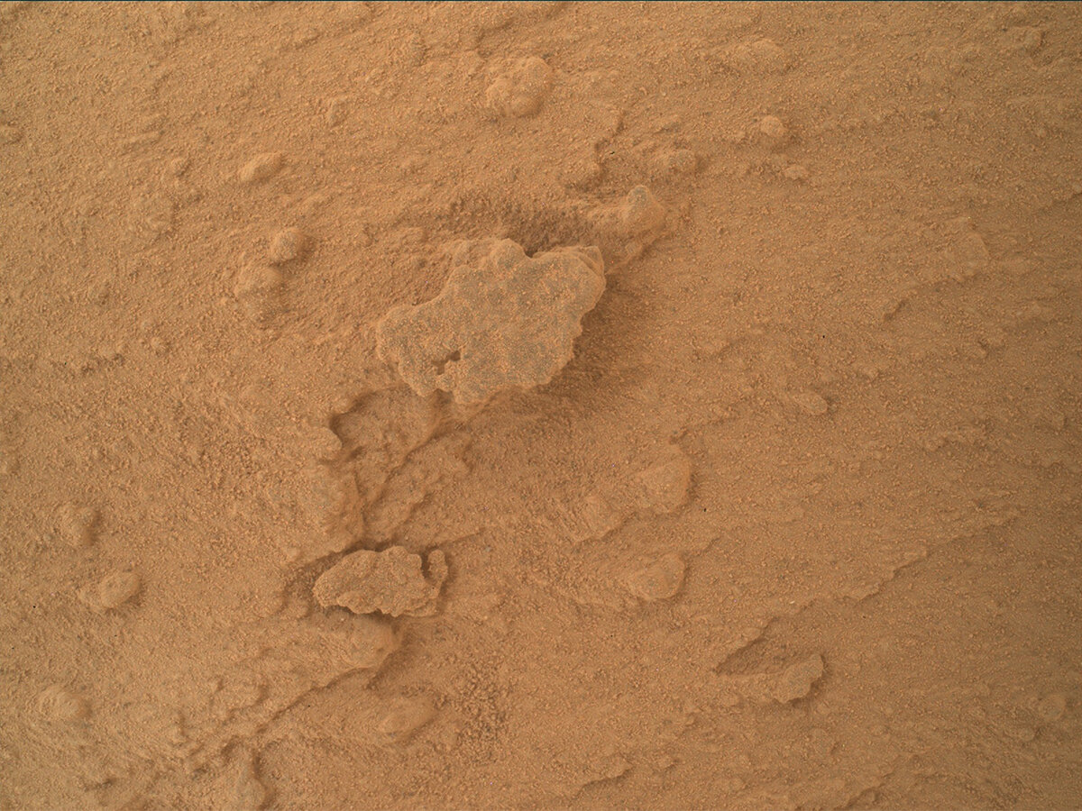
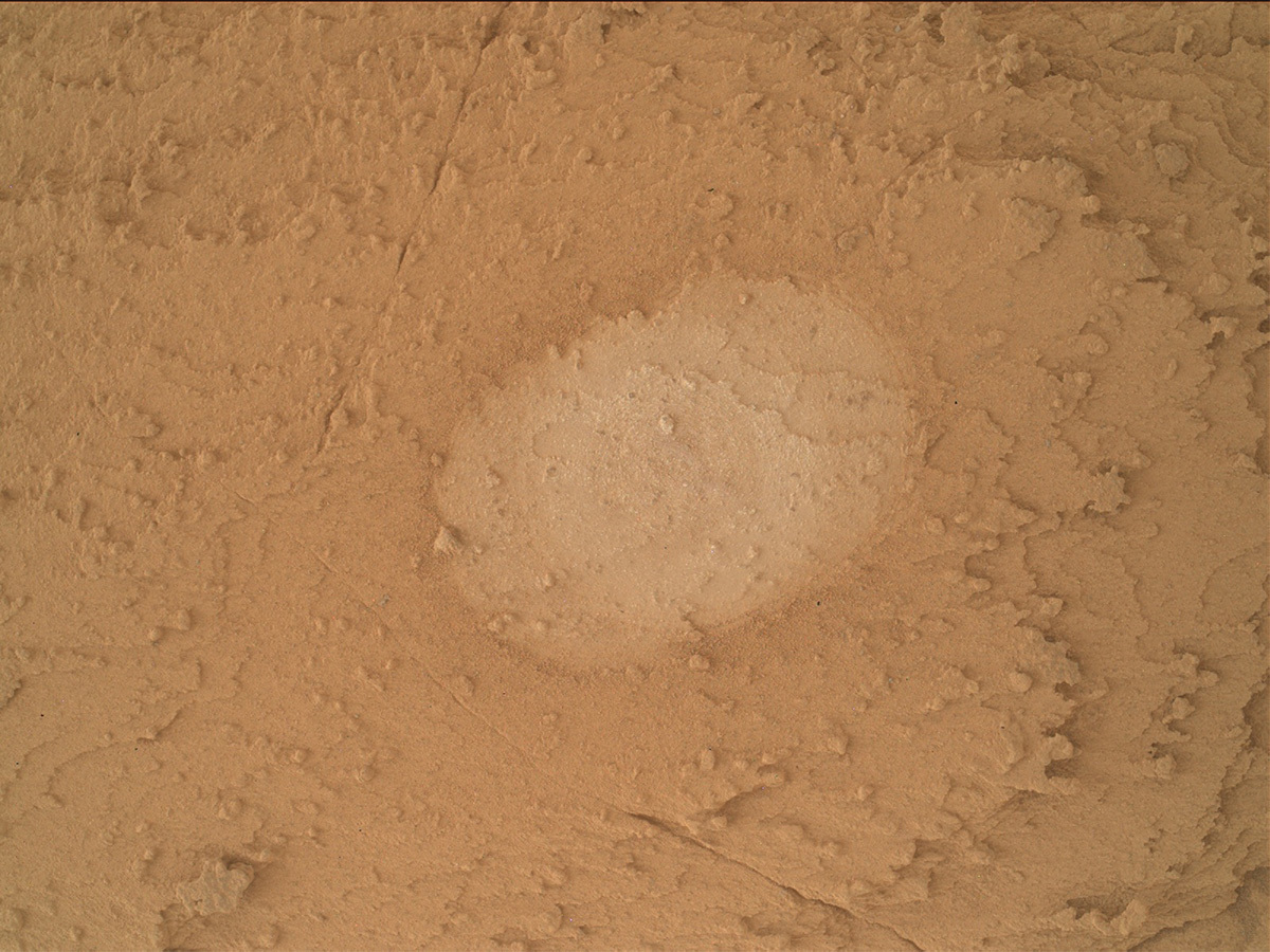
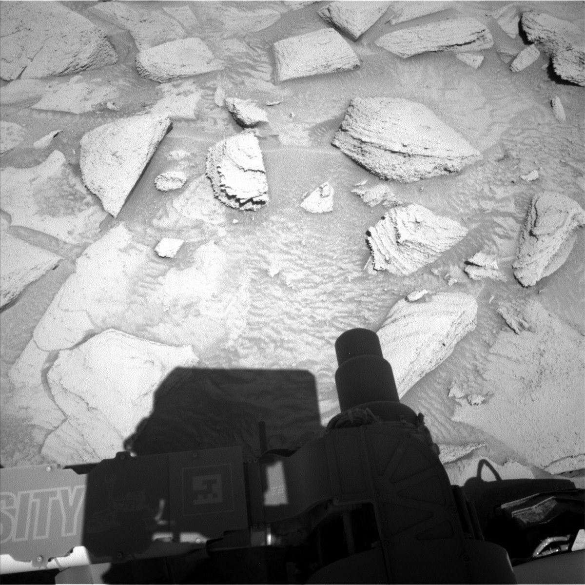
MAHLI image of “Ilha Grande." Credits: NASA/JPL-Caltech/MSSS. Download image ›

Earth planning date: Friday, May 12, 2023

Drilling campaigns force us to sit and stop, whilst the Ubajara” drill sample is analyzed. This takes a week or two, depending on the types of analysis that CheMin and SAM chose to do. This might sound like we are sitting quietly, just waiting but drill campaigns are furiously busy and “power hungry.” CheMin planned the first part of their analysis on Wednesday, and today, they added a second set of analysis, integrating over the drilled “Ubajara” sample. SAM will do a “preconditioning” activity, which sets SAM up for analysis next week. These activities are power intensive, which constrains what GEO and ENV can fit into the plan.

Often, we leave a workspace with regret – there are only so many hours in a given day, and even though a given sol (day) on Mars is longer than one on Earth, we almost always identify more targets than we can possibly fit in! So GEO is taking the opportunity here to analyze everything that ChemCam can reach.

Today’s plan focuses on small raised resistant features. Earlier this week, APXS analysed a really small nodule feature at “Ilha Grande,” shown in the accompanying MAHLI image and there was interest in analyzing this target with ChemCam’s LIBS instrument, which is well suited to hitting these types of targets. ChemCam will use LIBS on Ilha Grande and a nearby larger mass of similar material (“Tucuma”) (which was too rough to analyze with APXS as it posed a danger to the instrument) in this plan. The raised features are so small (Ilha Grande is 1 cm at its widest point) that they are hard to target with any great confidence, so targeting this early in our Ubajara stop will allow them to be refined and repeated if necessary. Mastcam will also image both ChemCam targets.

In parallel to the GEO themed part of the plan, the ENV group will also uplink several environmental activities. Mastcam will take two change detection images. These are typically done when we are stopped in a place for a few days. Taking images at the same time of day on a number of consecutive days allows us to see how much sediment is moving in our workspace, giving us an idea of wind directions and strengths. Navcam will also look for indirect evidence of winds, through “dust devil” movies which can also tell us about wind direction and strength. Mastcam will take a “crater rim extinction” image and a full tau measurement, to measure dust both within the crater and overhead in the atmosphere, whilst Navcam will survey clouds above us. The ENV portion of the plan is rounded out by REMS and DAN activities, looking at temperatures (REMS) and potential traces of hydrogen (DAN).

May 11, 2023

Sols 3825-3826: Another Beautiful Hole on Mars

Written by Ashley Stroupe, Mission Operations Engineer at NASA's Jet Propulsion Laboratory
This image of Curiosity's drill was taken by Front Hazard Avoidance Camera (Front Hazcam) onboard NASA's Mars rover Curiosity on Sol 3823. Credits: NASA/JPL-Caltech.

This image was taken by Front Hazard Avoidance Camera (Front Hazcam) onboard NASA's Mars rover Curiosity on Sol 3823. Credits: NASA/JPL-Caltech. Download image ›

Earth planning date: Wednesday May 10, 2023

Coming in for sol 3825 planning today, the team was very excited to see that we successfully drilled a new hole on the Ubajara target. The image shows the drill contacting the rock, just before beginning the drilling activity.

On the first sol of the plan, we begin with some imaging. We take a stereo mosaic of the target “Kukenan” to document the bedding of the local bedrock. We also take ChemCam and Mastcam post-drill observations of the drill target, Ubajara, to see the drill hole and the drill tailings. There is also a Navcam large dust devil survey and a Mastcam image of the CheMin inlet before we drop off sample. Normally we take images of the CheMin inlet immediately before and after sample drop-off. This time we are doing the sample drop-off at night in order to minimize the time between dropping off and analysis. As a result, we have to take the images of the inlet outside of the arm activities. After a nap, Curiosity wakes up to drop off the sample to CheMin for an overnight analysis. Science is very anxious to see how this sample differs from Tapo Caparo, which was about 25m lower in elevation than the Ubajara location. A few hours later, CheMin will proceed with analyzing the sample.

On the second sol of the plan, we are trying to conserve power for an expected upcoming SAM observation on the sample. We have some imaging, including Mastcam imaging for change detection on the target Azufral (which we observed in the prior plan), and a stereo mosaic to extend our workspace coverage, and the image of the CheMin inlet after the drop-off. ChemCam takes a LIBS observation and Mastcam a single supporting image of the target “Jaru,” a nodular bedrock target nearby. In this block is also an Navcam atmospheric observation, line-of-sight facing north. Lastly, ChemCam takes an RMI long-distance image of the inverted channel, near the area the rover may approach in the future.

May 9, 2023

Sols 3823-3824: A Green Light for Drilling Ubajara

Written by Sharon Wilson Purdy, Planetary Geologist at Smithsonian National Air and Space Museum
This image was taken by Chemistry & Camera (ChemCam) onboard NASA's Mars rover Curiosity on Sol 3822.

This image was taken by Chemistry & Camera (ChemCam) onboard NASA's Mars rover Curiosity on Sol 3822. Credits: NASA/JPL-Caltech/LANL. Download image ›

Earth planning date: Monday, May 8, 2023

A lot of preparation goes into assessing a potential drill site on Mars, and the “Ubajara” target got the usual treatment. Over the past several sols, Curiosity has diligently characterized the potential “Ubajara” drill site with activities such as MAHLI and APXS, brushing it with the dust removal tool, and completing a “preload” test. The preload test presses the rover arm down on the rock to get an idea of how the rock will react under the pressure of drilling.

Today was an exciting planning day. The science team mapped out two different plans for Sols 3823 and 3824 because the decision to drill hinged on the results of the preload test; we wanted to be prepared with a full slate of alternate activities if the drilling was moved to Sol 3825. Thankfully, we got the green light to drill “Ubajara” on Sol 3823 just in time to deliver the plan to the rover! The team is looking forward to learning more about this interesting light-toned bedrock to understand how its chemistry fits into the larger rock record in Gale crater.

On Sol 3824, Mastcam will follow up with multispectral imaging of the drill tailings (the small pieces of pulverized rock removed from the drill hole) and a gray fracture or vein named “Charvein.” Mastcam stereo mosaics of the workspace (the area in front of the rover) and the Gale crater rim in distance are also in the plan, as well as a Mastcam full tau that measures the amount of dust in the atmosphere. Lastly, ChemCam LIBS will characterize the regularly laminated, nodular bedrock of the “Arapira” target.

Back here on Earth, we will be anxiously awaiting to see the new “Ubajara” drill hole on Mars!

May 5, 2023

Sols 3821-3822: Check... And Double Check...

Written by Catherine O'Connell-Cooper, Planetary Geologist at University of New Brunswick
This is a MAHLI image of the brushed, flat and oval-shaped Ubajara potential drill target taken on sol 3819.

MAHLI image of the brushed Ubajara potential drill target, sol 3819. Credits: NASA/JPL-Caltech/MSSS. Download image ›

Earth planning date: Friday, May 5, 2023

We continue our triage of the “Ubajara” potential drill site in this plan. In the last plan, we brushed the surface and did some further investigation of Ubajara’s chemistry and structure (APXS, ChemCam and MAHLI). Information that came down this morning indicated that the target appears to be representative of what we have been seeing recently, as we climbed up the Canyon from the Marker Band.

In this plan, the Rover planners (RPs) planned a “preload” test, to get an idea of how the rock will behave when drilled. This involves putting the target under some pressure to make sure the rock is stable and safe to drill. MAHLI will then take two documentation images which hopefully will show no changes!

Curiosity won’t be sitting idly for the rest of the weekend. APXS and MAHLI are investigating a patch of darker material at "Ilha Grande” and some adjacent bedrock at “Ilha Grande offset” for comparison. MAHLI is also imaging the target “Bwesse Kiiki” which was analyzed by ChemCam’s LIBS instrument on sol 3818 (Tuesday of this past week).

Meanwhile ChemCam will analyze some nodular bedrock just beyond the Ubajara bedrock block at “Carajas” and will take a long distance image (“LD RMI”), looking ahead to Gediz Vallis, a large ridge feature which has been high on our “dream list” of places to go in Gale since before landing. This ChemCam RMI will focus on an area of large stones and boulders which were identified in previous images. We have been talking about the science we would do here for so many years, it's hard to believe we are close enough to identify individual stones and boulders! Mastcam is acquiring a “9x3 mosaic” (3 rows of 9 images) of fractured light toned rocks ahead of us in our future drive direction. These are close to some small impact craters, so we are interested to look at the fractures and see if they are related in any way to the craters.

ENV and Mastcam will monitor dust with a “crater rim image” and two tau measurements. These help to quantify the abundance of dust in the atmosphere. ECAM will add several images to characterize active environmental conditions in Gale, looking at clouds and searching for dust devils. DAN and REMS round out the environmental monitoring, measuring hydrogen concentrations (DAN) and temperatures (REMS).

May 3, 2023

Sols 3819-3820: Brushing Ubajara

Written by Ken Herkenhoff, Planetary Geologist at USGS Astrogeology Science Center
This image of Mars rocks and part of the Curiosity rover was taken by Right Navigation Camera onboard Curiosity on Sol 3817.

This image was taken by Right Navigation Camera onboard NASA's Mars rover Curiosity on Sol 3817. Credits: NASA/JPL-Caltech. Download image ›

Earth planning date: Wednesday, May 3, 2023

Tactical planning started an hour and a half later than usual this morning, because we had to wait for better-illuminated Navcam images of the Ubajara block (seen at bottom center in this image). The Rover Planners needed these better images to determine whether the Ubajara target can be brushed using the DRT, and promptly confirmed that they are GO for brushing! This was good news, because the MSL science team agreed that MAHLI images and APXS chemical data will be useful in deciding whether or not to drill at Ubajara. So the Sol 3819 plan is focused on contact science, but first Mastcam will acquire stereo mosaics of nearby layered rocks at Chenapau and extended coverage of the arm workspace. Then ChemCam will sample the elemental chemical composition of a nodular bedrock target named "Buritis" and acquire a long-distance RMI mosaic of the "Kukenan" outcrop. The Right Mastcam will then document the LIBS spots on Buritis and Navcam will characterize the dust content of the atmosphere toward the north before the arm is deployed to acquire a full suite of MAHLI images of the brushed spot. The APXS will be placed on and just off the brushed spot for evening integrations.

On Sol 3820, Mastcam will take a multispectral observation of the brushed spot and Navcam will search for dust devils. Then ChemCam will get busy, first shooting its laser at the brushed spot, then acquiring passive spectra of the sky, and finally taking a long-distance RMI mosaic of part of the Chenapau hill. Mastcam will then document the LIBS spots on Ubajara and measure the amount of dust above the rover. The rover will take a well-earned nap before waking up for an overnight measurement of atmospheric chemistry that should be very helpful in analyzing the ChemCam passive sky spectra. It was a busy planning day for me as SOWG Chair, and I'm glad that we were able to fit all of these activities into the power-constrained plan!

May 2, 2023

Sols 3817-3818: Examining a Potential Drill Spot

Written by Alex Innanen, Atmospheric Scientist at York University
This image of part of the Curiosity Rover and its shadow above the Mars surface was taken by Left Navigation Camera onboard NASA's Mars rover Curiosity on Sol 3815.

This image was taken by Left Navigation Camera onboard NASA's Mars rover Curiosity on Sol 3815. Credits: NASA/JPL-Caltech. Download image ›

Our weekend drive got us into a good position to attempt to examine a block we might attempt to drill. We don’t dive right in; we have to make sure this is in fact where we want to drill. This means contact science on “Ubajara,” which you can see on the left of the image above. The GEO team spent some time picking a special target name, which involved looking at pictures of national parks. Ubajara (a national park in Brazil), it was decided, is a great choice – it’s a bit more lush and green than Gale Crater, but the mountains and canyons are reminders of the canyon Curiosity just climbed out of.

We had planned a pretty typical drill sol 1, with MAHLI and APXS on the drill target, and a brush with the dust removal tool, but then learned that we will not be able to use the DRT until we get more images of this target. Luckily, we were still able to move forward with the other activities in the plan and still prepare to examine this block to decide if we want to drill it in the future.

The plan starts with a couple ENV activities – looking back towards the crater rim to measure the amount of dust in the atmosphere, and then scanning for dust devils. Then Mastcam and ChemCam will both image Ubajara in advance of the contact science. After contact science, ENV has afternoon observations to try to catch some clouds.

The next sol again starts with ENV – this time with targeted cloud and dust devil movies. Then ChemCam has a LIBS observation of “Bwesse Kiiki,” and a long distance RMI mosaic on a ridge to the north. Mastcam is also documenting the ChemCam LIBS target and doing multispectral imaging on the layered block “Ekeni.”

May 1, 2023

Sols 3814-3816: Just a Little Scoot!

Written by Elena Amador-French, Science Operations Coordinator at NASA's Jet Propulsion Laboratory
NASA's Mars rover Curiosity took 4 images in Gale Crater using its mast-mounted Right Navigation Camera (Navcam) to create this mosaic.

Sol 3812 - Right Navigation Camera, Cylindrical Projection: NASA's Mars rover Curiosity took 4 images in Gale Crater using its mast-mounted Right Navigation Camera (Navcam) to create this mosaic. Credits: NASA/JPL-Caltech. Download image ›

We arrived this morning to Curiosity at a new location with some bright toned, and more rounded rocks in our vicinity. Unfortunately, we could look but not touch as our wheels were positioned such that we could not safely unstow the arm for contact science. We typically have a large suite of arm activities in weekend plans but with those now removed, the science team had ample power and time to do remote sensing.

On the first sol, we will use Mastcam to image the target “Ekeni,” a target just in front of our right front wheel with interesting rhythmic textures – could they be due to how the sediment was originally emplaced or how it has since eroded? Similarly, the target “Fazendinha” appears to represent a transition between rock textures. These high resolution Mastcam images will allow our scientists to consider the history of these blocks. We’ll also use our ChemCam instrument to provide compositional information for the target “Sao Miguel,” giving us our first “taste” of the bedrock in front of us.

On the second sol, we continue to investigate the area around us with more Mastcam and another ChemCam LIBS observation on “Sao Tome” before taking a short drive – a scoot of just a few meters – to a potential sampling location. Mastcam will document this new location with a 360-degree mosaic, capturing all the terrain that surrounds us.

On the third sol of the plan, ChemCam will use its autonomous target selection capability, AEGIS, to collect compositional data from our new location.

As is typical for our weekend plans, we will take a suite of environmental monitoring measurements – searching for dust devils with our navigation camera, studying the dust opacity in the atmospheric with Mastcam and our engineering cameras, as well as our regular cadence of REMS observations.

In addition to these remote sensing activities, we also planned two CheMin activities to set ourselves up for potential sampling next week. Both activities are intended to ensure our instrument is as clean and prepared as possible to accurately measure mineralogy. We’ll vibe CheMin’s inlet funnel, as well dump any potential remaining sample from the cell we intend to deliver our next sample to.

April 26, 2023

Sols 3812-3813: Tiny Sticks Poking Out at Us

Written by Susanne Schwenzer, Planetary Geologist at The Open University
This image of ripples in the sandy Mars terrain and part of Curiosity visible was taken by the Curiosity rover on Sol 3810.

This image was taken by Left Navigation Camera onboard NASA's Mars rover Curiosity on Sol 3810. Credits: NASA/JPL-Caltech. Download image ›

I am ‘shadow’ Geo science team lead (GeoSTL) today, helping a new colleague to learn the details of the role. It’s so amazing that we train the next generation, in year 11 of our mission. I still remember my own training, as I wasn’t part of the initial cohort of GeoSTLs. Inspired by watching my colleague doing a great job, I went back through my notebook, and found out that one of the earliest sol plannings I have notes from are sols 1412 and 1413! What a nice coincidence, and looking back at Ken’s blog and my notes, those actually have the same target names all lined up. Coming back along memory lane from 2016 to today’s reality, we’ve got a busy two sol plan with some terrain features that keep the engineers well awake without the need of any caffeine!

Above, you can see parts of the terrain in front of us: we have sand, and we have rocks that were described as ‘poky-sticky’ when describing all the little protruding features. Of course, that makes it harder to place our contact instruments than a smooth surface would be. But those features are also very interesting as they often indicate a difference in hardness between different parts of the rocks. This could be a result of water-rock interactions depositing different minerals in different parts of these rocks. And that’s clearly of great interest to the team in our quest to understand the environmental conditions at the time the rocks formed. The engineers who place our arm are clearly awake as they managed to find us a spot on which we can safely use our DRT, the dust removal tool. And that’s despite all those little protruding features. Well dusted off, APXS and MAHLI will investigate the target ‘Armero,’ which is a bedrock target. ChemCam tries to cover the variability of the area by investigating a different target, namely target ‘Dona Juana.’ After the drive, ChemCam will also perform a LIBS investigation for which the rover picks the targets by itself before we see the end of drive images here on Earth. Those are known within the team as AEGIS. (Something we also did back in sols 1412 and 1413!)

There is, of course, a lot of imaging going on as the area is so interesting and we are still on the lookout for the transition between two units that is indicated by different rock textures. We see the difference in the appearance of the rocks around us to the rocks at a distance, but the many boulders and the nature of the terrain mean that we cannot see all the details until we are right there. So, lots of images and also a MARDI sidewalk it is. If you’ve never seen that term, here is what that means: normally MARDI takes one image when the rover has stopped after its drive. This is to document the terrain the rover is standing on. In a MARDI sidewalk, the rover takes many images along the way, resulting in one continuous strip of ground images – think of it like a panorama, but of the ground under the rover wheels instead of the landscape around it. That will help us see any changes that might occur during the drive.

Mastcam is very busy these sols, with a multispectral image on the APXS target ‘Armero,’ a documentation image on the ChemCam target ‘Dona Juana’ and two small stereo mosaics on ‘Awalapa’ and ‘Almerina Scour’ as well as a larger mosaic called ‘Almerina region.’ Of course, we also have atmospheric investigations in the plan, busy as always!

The drive should get us into an area with the other rock textures, but given the bouldery terrain, which also has lots of sand patches, the rover cannot just beeline to where we want it to be. Instead, the engineers will carefully evaluate every turn of the wheels to avoid pointy rocks and also slipping on the sand. As a consequence, it is hard to judge from our current vantage point where exactly on the rover’s tortuous path the rock features will change. We shall stand by in anticipation until we see the images. Exciting times climbing in a canyon on Mars … comfortably from my office chair!

April 25, 2023

Sols 3810-3811: Full Speed Ahead... Carefully!

Written by Catherine O'Connell-Cooper, Planetary Geologist at University of New Brunswick
This image was taken by Left Navigation Camera onboard NASA's Mars rover Curiosity on Sol 3808.

This image was taken by Left Navigation Camera onboard NASA's Mars rover Curiosity on Sol 3808. Credits: NASA/JPL-Caltech. Download image ›

As the blog for sols 3807-3809 noted, we have cleared the canyon! The accompanying Left Navcam image shows the view back down the canyon, showing all those tricky rocks we had to climb over. You can even spot some wheel tracks further back down if you peer vey closely. We don't exactly have free-wheeling territory up ahead in our drive direction, but it is a little flatter. This hopefully will give us better views of the path ahead and reduce slippage as we drive, so that we can drive for longer than we have been recently – today, the RPs planned a 25 metre drive, much more ambitious than recent drives! We also will hopefully have a higher rate of passing our "SRAP" test (this stands for Stability Risk Assessment Process and is the way we evaluate rover stability) up here than we did last week as we climbed the canyon. If we fail SRAP, we cannot use the arm instruments MAHLI and APXS – and for me, as a scientist on the APXS team, that’s always disappointing.

Fortunately, our weekend drive was successful – it took us where we had planned to go, ending with some solid workspace and safely parked to allow us to take the arm out for contact science. This bedrock has strong laminations apparent along its side and a flat top (seen here in this Left Navcam image of the workspace). The flat top is smooth enough for brushing, so we will DRT "Anortosito Repartimento" before taking MAHLI images, analyzing with APXS and getting a Mastcam multispectral image, all centred on the same spot for maximum science return.

ChemCam will use its LIBS instrument to look at an interesting fracture face, which looks like an upturned smile in the workspace image. "Galeras" is centred on the far right corner of the fracture, where the fracture is thickest. ChemCam will also take a long distance image ("LD RMI") looking much further afield to "Gediz Vallis ridge." These LD RMI can acquire a lot of detail from a great distance, helping to inform discussions about future science campaigns and potential drive directions.

Mastcam will take two mosaics close to the rover, a smaller mosaic looking at a laminated target ("Vichada") to the right of the workspace, and a larger mosaic covering the main block in our workspace (including the ChemCam and APXS/MAHLI targets) and the way that sand has gathered in a trough feature around the block.

Further afield, Mastcam will get an observation of the stratigraphy of the Chenapau butte and some interesting wind scour patterns just beyond today’s workspace.

ENV continue to monitor environmental conditions in Gale. In addition to our routine DAN and REMS measurements, Mastcam will acquire three tau measurements, which help to constrain the amount of dust in the atmosphere. Navcam will take a "dust devil" movie, in the hopes of catching a wind vortex in action.

April 24, 2023

Sols 3807-3809: We Made It to the Top!

Written by Kristen Bennett, Planetary Geologist at USGS Astrogeology Science Center
This image was taken by Front Hazard Avoidance Camera (Front Hazcam) onboard NASA's Mars rover Curiosity on Sol 3805.

This image was taken by Front Hazard Avoidance Camera (Front Hazcam) onboard NASA's Mars rover Curiosity on Sol 3805. Credits: NASA/JPL-Caltech. Download image ›

It always feels great to reach the top of a mountain, especially when the path was challenging. While the top of Mt. Sharp still looms above Curiosity, the team was very excited to see that in the last drive the rover successfully reached the top of the canyon that it has been climbing for the past few weeks. After the previous drive fell short of the top of the canyon in marker band valley, in the most recent plan Curiosity rose above the challenge of this terrain to reach the plateau above the canyon. And what a view! (See the front hazcam image displayed above.)

The workspace includes several interesting rocks, including the “Floresta” target which will be cleared of dust by the DRT and then observed by APXS, MAHLI, and Mastcam with a multispectral image. APXS and MAHLI will also target “Calama,” which is a rock that appears to have a dark coating on it. A dark toned float rock lies beyond the reach of the arm, so ChemCam will target it (“Ile Portal”) for a LIBS observation and Mastcam will take a corresponding image. A ChemCam RMI mosaic will document the structure and texture of contact between two units in the distance that were mapped from orbital images. Mastcam will also take several stereo observations, including at “Camopi” documenting dark rock textures and their relationship to underlying units, at “Limao” assessing rock textures, and at a location exhibiting interesting patterns in the rocks behind the rover.

The plan also includes coordinated ChemCam passive sky and APXS and SAM atmospheric observations. These measurements from three different instruments will be used together to constrain trace elements that are present in the martian atmosphere.