June 5, 2023

Sols 3848-3850: Boulder, Meet Wheel

Written by Ashley Stroupe, Mission Operations Engineer at NASA's Jet Propulsion Laboratory
This image of the Curiosity rover's wheels on the Mars surface was taken by Left Navigation Camera onboard NASA's Mars rover Curiosity on Sol 3846.

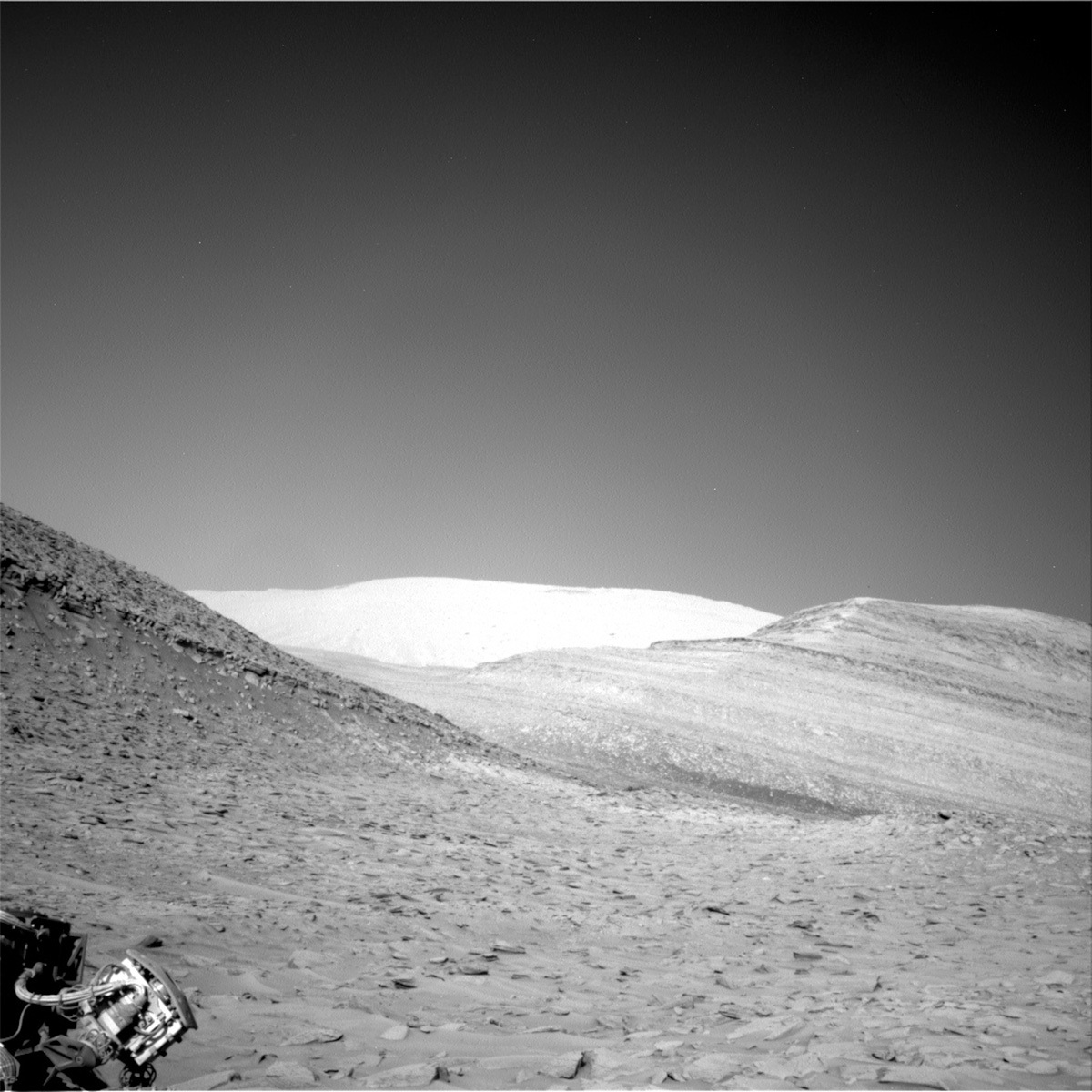
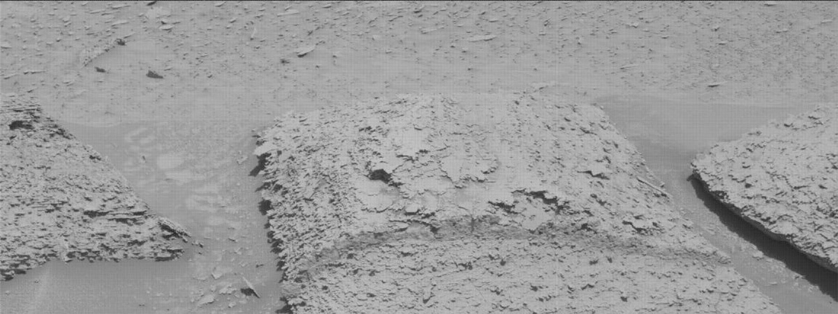
This image was taken by Left Navigation Camera onboard NASA's Mars rover Curiosity on Sol 3846. Credits: NASA/JPL-Caltech. Download image ›

Earth planning date: Friday, June 2, 2023

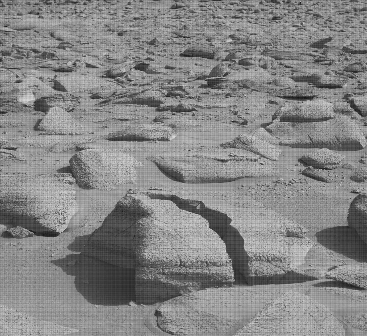
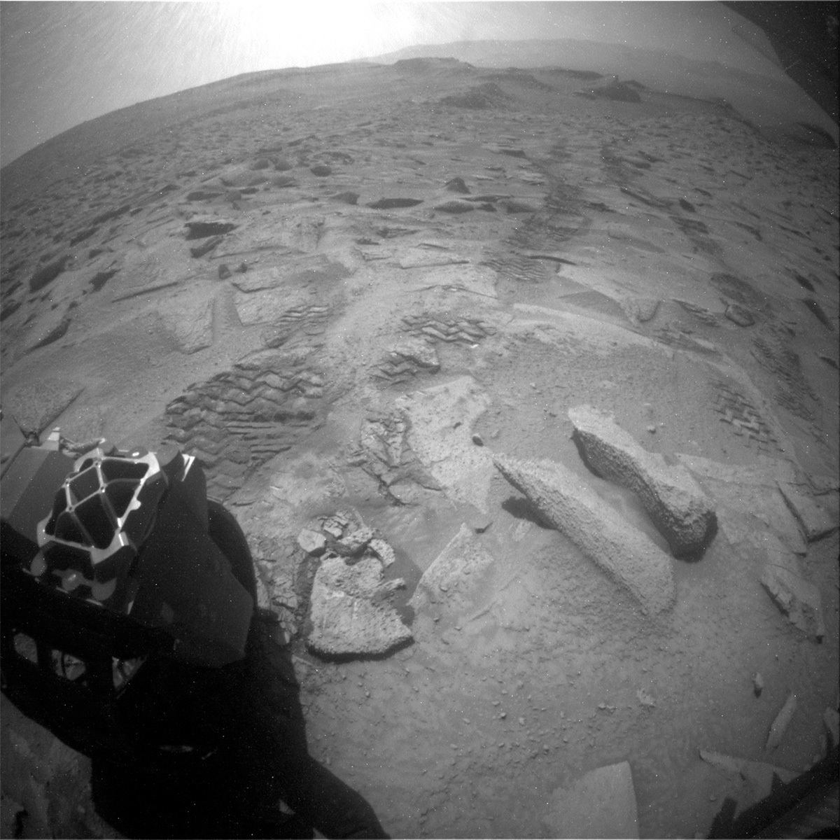
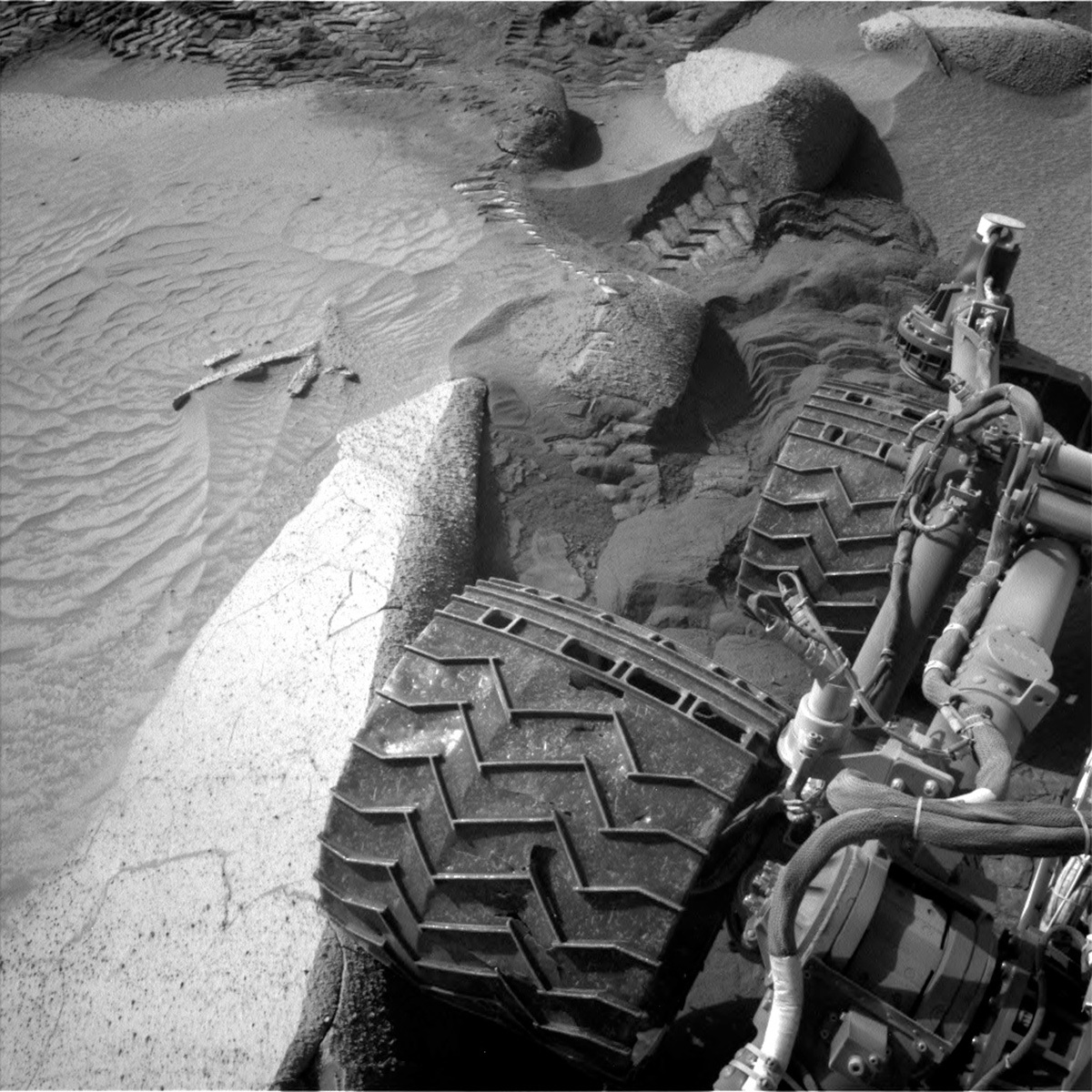
Today, when the team came in for planning our 3-sol weekend plan, we discovered the terrain had bitten us once again and ended the drive early. The rover’s right middle wheel was perched on a rock (see the image), making it unsafe to do the arm activities and contact science we had planned. The team quickly pivoted to taking a lot more imaging, along with continuing to push through this difficult area.

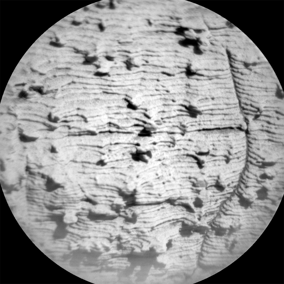
On the first sol of the plan, we take a lot of imaging. We start off the day with a Navcam line-of-sight image to look at the dust in the atmosphere. Next, Mastcam takes a stereo image of the sand ripple next to the rover that has been so challenging to get through. Mastcam is also taking stereo imaging of a scour feature and a nearby fractured rock, which can tell us about how rocks weathered. ChemCam then makes a LIBS observation of the rock “Cerro Bravo,” which is a piece of bedrock with nodules, followed up by a Mastcam documentation image. After a nap, the rover wakes up to take some additional afternoon atmospheric observations including a cloud observation, and some other sky imaging. After another nap, around sunset, Curiosity will wake up for a SAM EBT (a monthly maintenance activity).

On the second sol of the plan, we do some additional targeted science. We start with more atmospheric observations, including Navcam dust devil movie and suprahorizon movie and a Mastcam of the sky as well. Then, Chemcam takes a 5x1 LIBS observation of the “Aloepi” target, which is another nodular block, and a RMI mosaic which shows boulder variation and distribution on the Gediz Vallis ridge, followed up with a Mastcam documentation image of Aloepi.

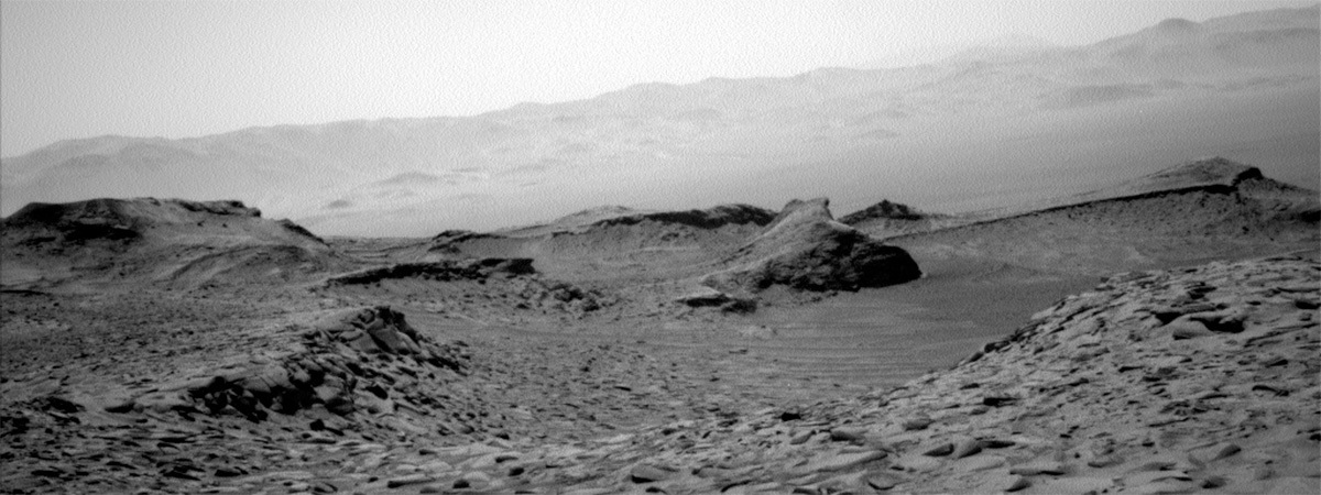
After the imaging, it is time to drive. The terrain here is very challenging because it has both big rocks and lots of sand, both of which can cause significant slip (the image also shows the rover tracks behind Curiosity, and it is evident how much the rover is sinking into the sand). Some of the rocks are also quite big and we do not want to drive over them – these can cause faults on the drive or even be dangerous to the rover. The Mobility Rover Planner (RP) needed a lot of time to try to figure out how get Curiosity out of the area where the last drive faulted and back onto the safest path forward.

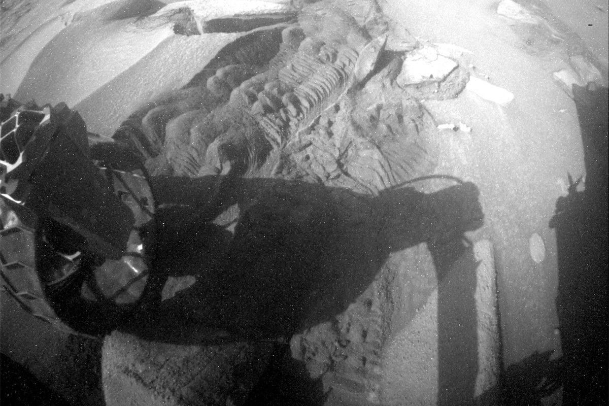
Just after the drive, we have a MARDI twilight image. These images can be really helpful to the RPs on tough terrain or when the drive faults because they provide an additional view under the rover, Later in the evening we do an APXS atmospheric observation, which we can do with the arm still stowed – fortunately in the stowed configuration the APXS is pointed in front of the rover, making this possible.

The third sol of plan has some additional imaging, Mastcam is taking a look at the rover deck to monitor dust accumulation. ChemCam is using AEGIS to look for interesting targets post-drive and also taking a sky observation. Lastly, Mastcam makes a solar tau observation to look at the sun and the dust in the atmosphere. After a relaxing night just waking up for communication with the orbiters to relay date, Curiosity wakes up early in the morning for some additional atmospheric observations, a Mastcam sol tau, and Navcam zenith and horizon imaging.

June 5, 2023

Sols 3851-3852: Slippery Science

Written by Natalie Moore, Mission Operations Specialist at Malin Space Science Systems
This image showing lumpy rock formations on the Mars surface was taken by Mast Camera (Mastcam) onboard NASA's Mars rover Curiosity on Sol 3846.

This image was taken by Mast Camera (Mastcam) onboard NASA's Mars rover Curiosity on Sol 3846. Credits: NASA/JPL-Caltech/MSSS. Download image ›

Earth planning date: Monday, June 5, 2023

There’s a special sort of hopeful-nervousness I feel on a weekend with a challenging drive. It's how I felt this last weekend, waiting for our rover to try and execute the 11 meter drive that was supposed to get us off a large rock precluding any arm activities over the weekend. Well, we did get off the rock (yay!) but our wheels still slipped in the surrounding sand and ended the drive early in approximately the same place as Friday (see our new orientation to the large rock). A dissatisfying outcome, but still progress as we continue to chug uphill through the slippery sand and boulders.

One happy surprise after such an outcome was the ability to use our arm, unlike last Friday. The APXS and MAHLI teams quickly decided to target a spot on the laminated bedrock in front of us for DRT and named it “Aporema.” The RPs were able to approve Aporema for DRT, APXS, and MAHLI activities rather quickly and the GEO team was just as efficient, delivering our plan 30 min early!

For these plans where we drive on the first sol and have early enough handover times (when the plan starts executing), we’re usually able to have two arm backbones “split” around one, midday remote science backbone before driving in the afternoon and taking our post-drive imagery before sunset - which right now is about 17:19 in Gale. So this plan starts ~10:00 with the DRT and following APXS integrations on Aporema, after which the remote science block starts ~11:40 and begins with two Mastcam multispectral stereo frames of the DRT spot and a wheel scuff we made during the weekend drive. ChemCam will then target another laminated bedrock target named “Calafate” for LIBS and Mastcam will document the attempt afterwards. Around ~13:10 in the afternoon the second arm backbone starts with MAHLI images of the DRT/APXS spot from 20cm, 5cm, and 1cm away from the target. That means we should get a highest resolution of ~17 µm/pixel (the width of fine/medium silt grains!) for Aporema.

After our targeted science is complete, the rover will attempt again to drive ~11 meters from this spot and get us in front of a new piece of bedrock for DRT on Wednesday. The post-drive imagery will happen ~15:30 and includes the Navcam full panorama, Hazcam images of the wheels, and a Mastcam medium-resolution mosaic of the workspace in front of the arm. And we could never forget to plan our MARDI image that happens post-sunset to document the terrain under our left-front wheel.

The second sol is much quieter and assumes we’re in a new location. In the blind, Mastcam will target the sun to measure atmospheric opacity and Navcam will target the horizon to capture any changes from dust movement. ChemCam will autonomously target a LIBS spot by finding a bedrock spot that’s far from any rover parts so there’s no collision risk. DAN, RAD, and REMS are taking atmospheric measurements all the while, continuing to characterize the current climate in Gale.

May 31, 2023

Sols 3845-3847: 30 Kilometers and Counting!

Written by Susanne Schwenzer, Planetary Geologist at The Open University
This image was taken by ChemCam RMI onboard NASA's Mars rover Curiosity on Sol 3843. Credits: NASA/JPL-Caltech/LANL. Download image ›

This image was taken by ChemCam RMI onboard NASA's Mars rover Curiosity on Sol 3843. Credits: NASA/JPL-Caltech/LANL. Download image ›

Earth planning date: Tuesday, May 30, 2023

What do you do when you are driving through challenging terrain? Well, hit a new record! Tosol we have passed the 30 kilometer mark! That’s a Mars rover milestone only the NASA Opportunity rover has reached so far. That was around June 2011 and just over 2610 sols into the mission with Opportunity on its way between Victoria and Endeavour Crater. At Endeavour crater Opportunity had driven a marathon on Mars – remember Marathon Valley? You can see the stunning panorama here. Way to go Curiosity!

Driving is especially difficult for Curiosity and the rover drivers right now. One of us remarked they wouldn’t want to walk through there, let alone drive, but our rover drivers did an excellent job not only getting us to the next stop, but also parking the rover with all wheels safely on the ground so that we could use the arm. If you want to get an impression on how big of a challenge that was, here is an image from the navigation cameras to illustrate it. And we are making best use of the opportunity investigating target “Cujubim” after using the DRT. There is a three spot APXS raster on the target and of course MAHLI documentation. In addition, MAHLI looks at the target “Cumbal” to further document the interesting sedimentary structures all around us.

For the image above, though, I picked a Remote Micro-Imager (RMI) image to illustrate some of those interesting things: it shows the sedimentary structures, all the laminae, but also the nodules within, which will tell us a full story of how those rocks formed, one lamina at a time, and then there must have been another watery event forming the nodules.

In today’s plan we have two more RMIs looking into the distance to discern more of those sedimentary structures. ChemCam also keeps its laser busy on two bedrock targets, both also with nodules, which have the target names “Cariacau” and “Crique Yolande,” and there will be an AEGIS after the drive. Mastcam has two multispectral observations, one on the DRT spot, and one on target “Crique Rubin.” Mastcam further images targets “Cariacau” and “Paleomeu River,” and another target in front of the rover both to further document all the interesting features around us. In addition, the environmental theme group conducts the regular atmospheric monitoring, and of course, DAN looks for water in the underground and MARDI takes an image after the drive. And now, raise a glass (or cup) with your favourite beverage to wish the rover well navigating all the boulders ahead!

May 30, 2023

Sols 3841-3844: Feeling the Churn

Written by Michelle Minitti, Planetary Geologist at Framework
This image of the rover's wheel shadow on the Mars surface was taken by Rear Hazard Avoidance Camera (Rear Hazcam) onboard NASA's Mars rover Curiosity on Sol 3839.

This image was taken by Rear Hazard Avoidance Camera (Rear Hazcam) onboard NASA's Mars rover Curiosity on Sol 3839. Credits: NASA/JPL-Caltech. Download image ›

Earth planning date: Friday, May 26, 2023

If you have ever had the experience of hiking up a sand dune, you can recall the feeling in your legs as you worked extra hard to stay stable and make forward progress as the sand shifted and moved beneath you. As you can see in the above rear Hazcam image, Curiosity had the same experience toward the end of her last drive. Her wheels churned through the sand she encountered as she drove uphill, carving a path and displacing half-buried rocks along the way. This kind of churn causes planning churn, upsetting plans for using the arm (and the instruments on it - DRT, MAHLI and APXS) for the long weekend. But the sand did not prevent the rest of the rover from taking in our surroundings!

The sand that hung Curiosity up also provided an attractive imaging target, with Mastcam mosaics planned across a large sand ripple next to the rover, and sand trough around one of the bedrock slabs near the ripple. Mastcam will acquire a 180+ degree context mosaic of the road ahead to support drive planning in this challenging terrain, and a multispectral observation of one the prominent veins that cuts through the bedrock in this area at "Kamani Kreek."

ChemCam also got in on the vein action with a raster across the “Sotara” vein. The host bedrock was not to be ignored, with one raster across representative bedrock at “Acai” (yum!), and a rough and bumpy version of the bedrock at “Muqui.” ChemCam RMI imaging looked slightly farther afield than Mastcam, with two long distance RMI mosaics on potential contacts on Gediz Vallis Ridge, and one mosaic on the yardang structures that top Mount Sharp.

Even farther afield, Navcam will acquire dust devil surveys, cloud movies, and atmospheric opacity observations across multiple sols and multiple times of day to keep building our temporal record of these phenomena. We were able to fit in more of these activities than usual due to leaving our power-hungry arm stowed. The extra power also meant that DAN could plan some extra long (4 and 6 hours!) passive measurements, and with the extra long plan to get us through the US holiday weekend, REMS got their own dedicated sol.

And finally, very close to home - within the rover itself! - CheMin will conduct its fourth analysis on the “Ubajara” sample. The more times CheMin can analyze the sample, the more detail the team can pull out from the data, and the better we refine our understanding of all of the mineral components in the sample.

May 24, 2023

Sols 3839-3840: Hitting the Road After Three Weeks at Ubajara

Written by Scott VanBommel, Planetary Scientist at Washington University
This image was taken by Rear Hazard Avoidance Camera (Rear Hazcam) onboard NASA's Mars rover Curiosity on Sol 3837.

This image was taken by Rear Hazard Avoidance Camera (Rear Hazcam) onboard NASA's Mars rover Curiosity on Sol 3837. Credits: NASA/JPL-Caltech. Download image ›

Earth planning date: Wednesday, May 24, 2023

May has been a busy month for Curiosity. Our rover has been hard at work since arriving at its current location around the first of the month. In the three weeks since, Curiosity has thoroughly characterized the area around "Ubajara" and completed another successful drill campaign, its 38th such accomplishment. Curiosity's work now lies ahead, and like many in the United States this long weekend, Curiosity will hit the road. While we do not anticipate any travel congestion (we'd have quite the drive before we encounter another vehicle on Mars), we remain on the lookout for fascinating stops along the way, particularly those that may provide us with further clues as to the ancient history of Gale crater.

In today's two-sol plan we started by extending Curiosity's robotic arm first thing in the morning and cleared an oblate area (roughly the size of a sticky note) of dust using the Dust Removal Tool (DRT). This exposed the rock target "Zipaquira" for APXS analysis early in the plan, permitting us to take advantage of the favourable cool morning temperatures as Gale crater approaches winter solstice. After the quick ~30 minute APXS activity was completed, Curiosity moved the arm, took Mastcam images of the DRT'd Zipaquira location, and left the arm out of the way for further ChemCam and Mastcam activities.

ChemCam investigated the target "Karipuna" before Mastcam documented both the APXS and ChemCam targets in the plan, ahead of additional imaging of the "Boa Hora" target. As lighting became more favourable around the middle of the day for MAHLI, Curiosity moved the arm back to Zipaquira and acquired four MAHLI images at various resolutions. With these images saved on board, activities at Ubajara were completed. Curiosity then commenced the next leg of its journey: a planned drive of 37 m. At the end of the drive Curiosity acquired the requisite imaging to ensure that Friday's planning team has everything they need for a comprehensive four-sol long weekend plan.

May 23, 2023

Sols 3837-3838: MAHLI Works the Night Shift

Written by Abigail Knight, Graduate Student at Washington University in St. Louis
NASA's Mars rover Curiosity acquired this image of a drill hole on the Mars surface using its Mars Hand Lens Imager (MAHLI), located on the turret at the end of the rover's robotic arm, on May 20, 2023, or Sol 3834.

NASA's Mars rover Curiosity acquired this image using its Mars Hand Lens Imager (MAHLI), located on the turret at the end of the rover's robotic arm, on May 20, 2023, Sol 3834 of the Mars Science Laboratory Mission. Credits: NASA/JPL-Caltech/MSSS. Download image ›

Earth planning date: Monday, May 22, 2023

Curiosity successfully wrapped up the “Ubajara” drill campaign over the weekend with some imaging of the drill tailings. This Monday, we are planning two sols (Mars days) of activities to finish up at Ubajara before driving off in the coming sols. Most targeted science today is focused on bedrock target “Apetina,” which is situated on the same block as our previous Ubajara drill target.

We start off with Navcam and Mastcam line-of-sight observations to assess the dust content in the atmosphere. ChemCam will use its laser to ablate and analyze soil target “Salamangone” with a technique called laser-induced breakdown spectroscopy (LIBS). ChemCam will also acquire a series of images with its Remote Micro-Imager to form a mosaic of upper Gediz Vallis ridge from a distance.

Curiosity will use its Dust Removal Tool (DRT) to first brush away the ever-present Martian dust coating Apetina, so other instruments can get a better look at the composition and features of the actual underlying bedrock. Mastcam will take lots of images after brushing the target to determine and document the success of the dust removal. Then, MAHLI will have a look at the brushed target, and APXS will analyze the elemental composition of Apetina with a combination of X-rays and alpha particles in the evening. Today was my first solo shift as the APXS Payload Uplink/Downlink Lead, so as operations wrap up, I’m eagerly awaiting the arrival of our APXS data from Apetina! Later, after the Sun has set on Mars, MAHLI will have a second look at Apetina – this time at night with LEDs rather than sunlight to illuminate the surface. As the original MAHLI PI once explained, “MAHLI’s white light illumination capabilities will be used to create glints, reduce shadows, create shadows, and thereby enhance observation of crystal faces.”

The second sol of our plan is full of observations of nearby bedrock, the distant crater rim, and the Martian atmosphere. Mastcam kicks things off on the second sol with some more imaging of Apetina and an extension of its mosaic of the local terrain surrounding Curiosity. ChemCam will then use the LIBS technique once more to investigate the surface of nearby bedrock target “Zipaquira” and investigate potential signs of past alteration. ChemCam’s last observation of this plan will be a mosaic looking toward “Peace Vallis,” located along the distant rim of Gale crater. Curiosity will also investigate the Martian atmosphere with a Mastcam Sky Survey and Navcam Dust Devil Survey.

May 22, 2023

Sols 3834-3836: Wrapping Up at Ubajara

Written by Conor Hayes, Planetary Scientist at York University
Image taken by Chemistry & Camera (ChemCam) onboard NASA's Mars rover Curiosity on Sol 3832.

This image was taken by Chemistry & Camera (ChemCam) onboard NASA's Mars rover Curiosity on Sol 3832. Image Credit: NASA/JPL-Caltech/LANL. Download image ›

Earth planning date: Friday, May 19, 2023

Today was what we call a "late slide" planning day, meaning that we started 90 minutes later than usual – 9:30 AM at JPL, or 12:30 PM for me here in Toronto. This change was necessitated by the fact that the data we needed to go ahead with planning wasn't scheduled to be downlinked from Mars to Earth until just after 9 AM PDT, well after our usual 8 AM PDT start time.

The biggest question coming into today's plan was whether or not the SAM team wanted to go ahead with their Gas Chromatography Mass Spectrometry (GCMS) experiment on the Ubajara sample after getting the results from the Evolved Gas Analysis (EGA) performed in Wednesday's plan. After taking a look at the EGA data between Wednesday and today, SAM decided not to proceed with GCMS. SAM activities consume a significant amount of the rover's battery charge, so removing GCMS from today's plan meant that we got some extra time to do other science. It also means that we will be wrapping up our time here at Ubajara just a little earlier than scheduled, so this weekend will be one of our last opportunities to take a look at this location before continuing to drive uphill.

On the first sol, we begin by extending our Mastcam mosaic of this location to document as much of the area as we can while we're still here, before turning Mastcam to look up Gediz Vallis in the direction that we will eventually be driving. ChemCam will then zap the target "Jutica" with LIBS, taking before and after images with its RMI camera. Post-LIBS, Jutica will be imaged by Mastcam. ChemCam RMI will also take a mosaic of "Peace Vallis," an old river valley that deposited material on the crater floor near our 2012 landing site. Once that is wrapped up, we will dump the Ubajara sample now that it is no longer needed by SAM. Finally, MAHLI and APXS will take a look at the Ubajara drill hole tailings.

The second sol's science begins with a number of Navcam environmental science activities, including a Line-of-Sight observation of the rim of Gale Crater to measure the amount of dust in the atmosphere, a Navcam cloud movie, and a survey for dust devils around the rover. LIBS and RMI will then turn their attention to Ilha Grande, which we have targeted with a number of instruments during our stay here at Ubajara. Mastcam will also image the drill boresight and bit assembly to assess their condition following the Ubajara drill campaign. APXS will conduct an overnight observation to characterize seasonal changes in the amount of argon in the Martian atmosphere.

The final sol is dedicated to a number of ChemCam activities, starting with another LIBS/RMI observation, this time of "Walterlandia." We then spend some time taking passive spectra of the sky to examine atmospheric aerosol properties as well as atmospheric abundances of oxygen and water vapor to complement the APXS overnight observations.

This plan wraps up with our usual weekend suite of early-morning atmospheric monitoring activities from the ENV team. This includes two Navcam movies to look for clouds above Gale and a Navcam 360 survey to characterize the microphysical properties of those clouds. We will also be measuring the amount of dust in the atmosphere above and within Gale with Mastcam and Navcam observations of the crater rim and the Sun. As always, REMS and RAD will spend this plan monitoring the weather and the radiation environment.

May 18, 2023

Sols 3832-3833: Remotely Waiting in Gale

Written by Natalie Moore, Mission Operations Specialist at Malin Space Science Systems
This image was taken by Right Navigation Camera onboard NASA's Mars rover Curiosity on Sol 3827.

This image was taken by Right Navigation Camera onboard NASA's Mars rover Curiosity on Sol 3827. Credits: NASA/JPL-Caltech. Download image ›

Earth planning date: Wednesday, May 17, 2023

As I’m writing this, it’s about 8:30 pm on sol 3831 in Gale crater: ~16 hours after our SAM instrument ran its EGA experiment (which Abigail described so clearly in yesterday’s blog!). While we were able to confirm the success of the Ubajara drill sample drop-off to SAM and the start of the EGA, our first communication with Earth after the EGA completed was delayed from a ground-based issue. Luckily, our downlink lead assured us that the data would be available later this evening so the SAM team can still assess the results before Friday’s next planning session. So for now, we’re still in a planning holding pattern until SAM decides if the Ubajara drill sample is tasty enough for further analysis.

My primary role in this mission is to operate the science cameras (Mastcam, MAHLI, MARDI), and drill sites usually provide more opportunities to watch our mission scientists analyze instrument results. Something I’ve noticed at Ubajara is that everyone's excited about the surrounding geological contacts and chemically-interesting veins/nodules in the bedrock around us. We’re also at a high vantage point of our traversed path, including Marker Band valley and its towering buttes like Deepdale, Bolivar, Amapa, and Chenapau - not to mention the crater rim shining through the fairly low atmospheric opacity (check out this Navcam 360 mosaic from last week)! All of this visible diversity means our remote science teams are eager to fill up the plan as much as our battery will let us.

For this two-sol plan we’re starting off with a Mastcam multispectral of the Jardinopolis dark vein target ChemCam shot with LIBS on sol 3830 (here’s the M100 image post-ChemCam LIBS). ChemCam is using their one-LIBS-per-sol on a bedrock target named “Les Trois Dents” (upper-left in this M100 image) and treating the clear atmosphere as an opportunity to get high-resolution imaging of the crater rim - supplementing Mastcam’s most recent observation on sol 3830. We’ll fill the evening and night of sol 3832 with environmental data collection from RAD and REMS and pick up in the afternoon of sol 3833 with more Mastcam images of the atmosphere for tau measurements, the drill fines for measuring wind presence, and the ChemCam LIBS shots for color context. ChemCam will shoot the same block we drilled on a target named “Madeira” for spectral diversity, and Navcam will take horizon movies to watch for any dust devils. We’ll finish out the plan with more environmental measurements and another CheMin analysis of some Ubajara drill sample to see if chemistry results differ over time. Our next plan’s fate now rests in the hands of the SAM team: to continue analyzing or wrap up this campaign and move on. We’ll know for sure on Friday morning, so put in your guess now and check back to see if SAM agrees!

May 16, 2023

Sol 3831: Awaiting SAM Results

Written by Abigail Fraeman, Planetary Geologist at NASA's Jet Propulsion Laboratory
This image was taken by Left Navigation Camera onboard NASA's Mars rover Curiosity on Sol 3828.

This image was taken by Left Navigation Camera onboard NASA's Mars rover Curiosity on Sol 3828. Credits: NASA/JPL-Caltech. Download image ›

Earth planning date: Tuesday, May 16, 2023

Curiosity is still hard at work analyzing results from the Ubajara drilled sample. Yesterday we delivered some of the sample to the Sample Analysis at Mars (SAM) instrument for an Evolved Gas Analysis (EGA), which is basically an activity where we bake the rock powder at very high temperatures (100s of degrees C) and simultaneously measure the compositions of the gasses that come off the rocks as it gets hotter and hotter and hotter. We planned to run the SAM EGA overnight in the sol 3830 plan, so we didn’t have the data of that experiment down in time for planning this morning to help us decide what we want to do next; our choices are either to do another kind of analysis of the sample with SAM, or wrap up this drill campaign and drive on. Today’s plan therefore turned into a “Wait for SAM” plan, where we planned some science activities for Curiosity to do while we recharge the battery and await data from the experiment to be returned to Earth.

Fortunately, there’s lots to do while we wait! Mastcam has been slowly collecting lots of beautiful and scientifically valuable high-resolution mosaics from this location, so today we will continue to add to the collection by adding coverage of some rocks in front of the rover. ChemCam has also been documenting some interesting dark nodules and veins on targets like Ilha Grande, Tacuma, and in Jardinopolis in the past weekend’s and yesterday’s plan. We’ll continue this characterization today with a ChemCam LIBS activity on another nearby dark vein, named “Sunsas.” On the environmental monitoring front, we’ll also look at the rim of Gale crater with Mastcam and Navcam to characterize how hazy it looks (it’s a very clear time of year right now, see above!), and also search for dust devils with Navcam.

May 16, 2023

Sol 3830: Balancing Act

Written by Lucy Thompson, Planetary Geologist at University of New Brunswick
This Mastcam image was taken onboard NASA's Mars rover Curiosity on Sol 3824, showing a possible ChemCam rock target.

Mastcam left image. ChemCam will target the dark material within the central block. Credits: NASA/JPL-Caltech/MSSS. Download image ›

Earth planning date: May 15, 2023

We are in the midst of our 38th successful drill campaign, analyzing the “Ubajara” bedrock, a sample of what we have been referring to as the “above Marker band” bedrock. Curiosity has been systematically analyzing the bedrock and associated vein and nodular features for chemistry, texture and sedimentology since we left the Marker band and our last drill target, “Tapo Caparo.” We are interested in documenting any changes as we drive up in elevation away from the distinctive Marker band, which may be indicative of changing depositional, or later alteration environments. By drilling Ubajara, which is ~25 m higher in elevation than Tapo Caparo, we can deliver sample to our internal instruments, CheMin and SAM, to further elucidate specific mineralogical and compositional changes, as well as investigate the presence of organic compounds. Today it is the turn of SAM to perform their EGA (evolved gas analysis). The SAM analysis requires significant power, so we must carefully balance the amount of power required by the different activities we wish to perform, with the SAM analysis of the Ubajara sample taking priority. This meant that we had limited time to perform other remote science activities, to enable to the rover to sleep and recharge for as long as possible prior to the SAM analysis.

The geologists and environmental scientists had no trouble filling the time available to them. ChemCam will analyze a dark, vein-like feature in the workspace, “Jardinopolis,” with accompanying Mastcam documentation imagery. Mastcam will also acquire images to extend existing coverage of the area surrounding the Ubajara drill site. To continue monitoring changes in the atmosphere, Mastcam will take two tau images to measure the dust in the atmosphere, and we will acquire a Navcam 360 sky survey and cloud altitude observation. Standard REMS, DAN and RAD activities round out this plan.

We are all eagerly awaiting the results of the additional CheMin and new SAM analyses of our latest, Ubajara drill sample!