September 28, 2023

Sols 3962-3963: Dust Removal Delayed

Written by Abigail Knight, Graduate Student at Washington University
This image was taken by Left Navigation Camera onboard NASA's Mars rover Curiosity on Sol 3960.

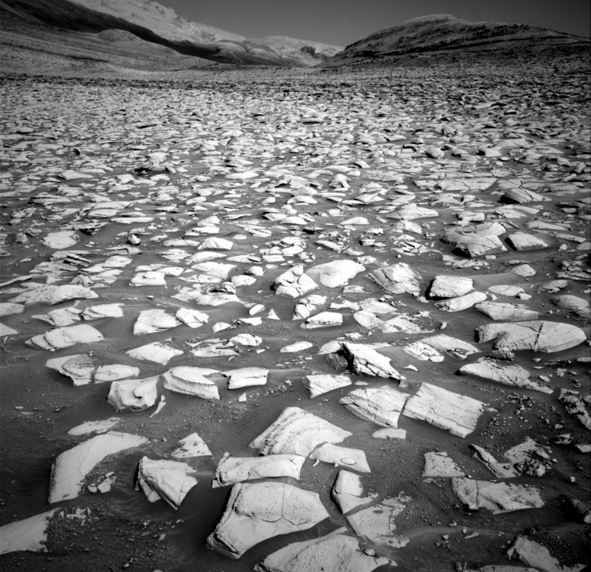
This image was taken by Left Navigation Camera onboard NASA's Mars rover Curiosity on Sol 3960. Credits: NASA/JPL-Caltech. Download image ›

Earth planning date: Wednesday, September 27, 2023

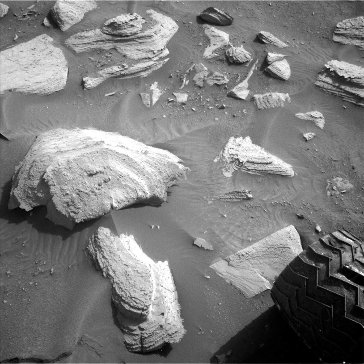
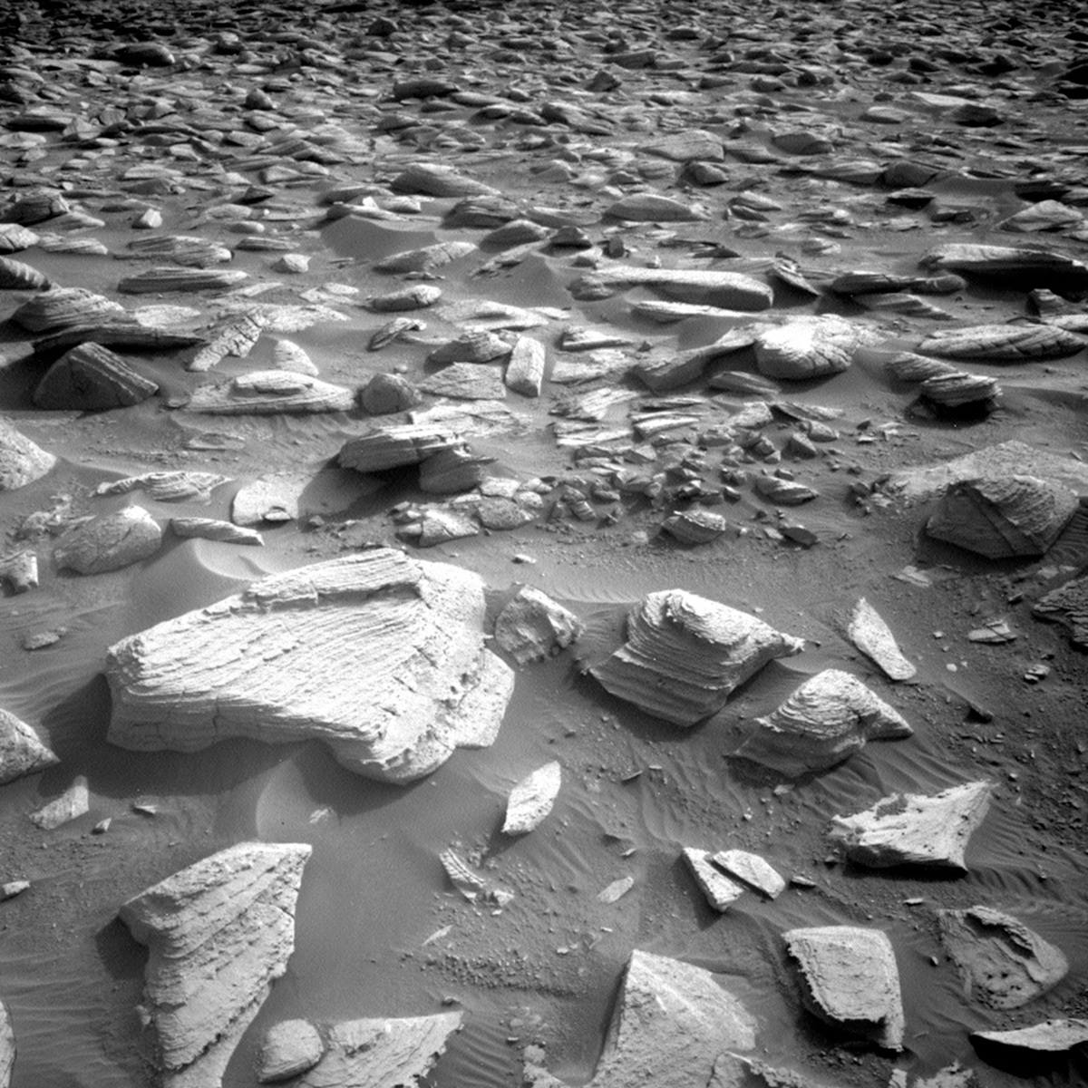
Our exploration of the light-and-dark-toned bands continues today as Curiosity has completed another successful drive and now has a promising block of light-toned bedrock in its latest workspace. With a thorough investigation of the compositions and textures within this region, we hope to identify what factors cause the differences between the light and dark bands as well as obtain more context for planning Curiosity’s next drill target.

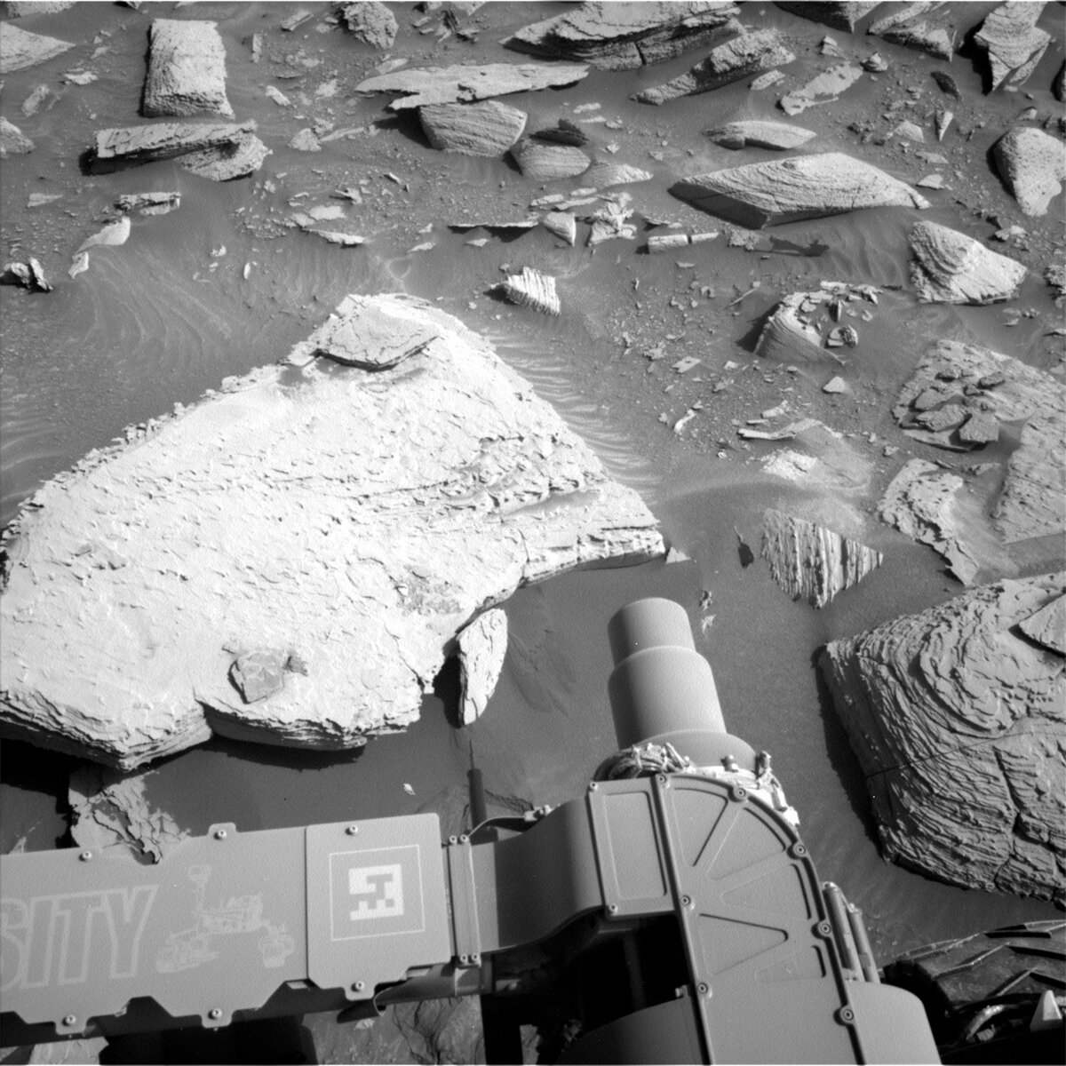
We learned at the start of planning today that Mastcam did not acquire the standard post-drive color imaging of the new workspace due to an issue with the placement of a thermal heating sequence in the previous plan. This precludes Curiosity from brushing any potential contact science targets with the Dust Removal Tool (DRT). We were then faced with the decision to either stay put and do contact science (without the DRT) on the nice block of light-toned bedrock in front of us or to drive on to a dark-toned band instead. After some discussion, we decided to remain at our current workspace, get the prerequisite imagery for using the DRT in the upcoming weekend plan, and take the opportunity to do some additional contact science activities on the unbrushed block in our workspace.

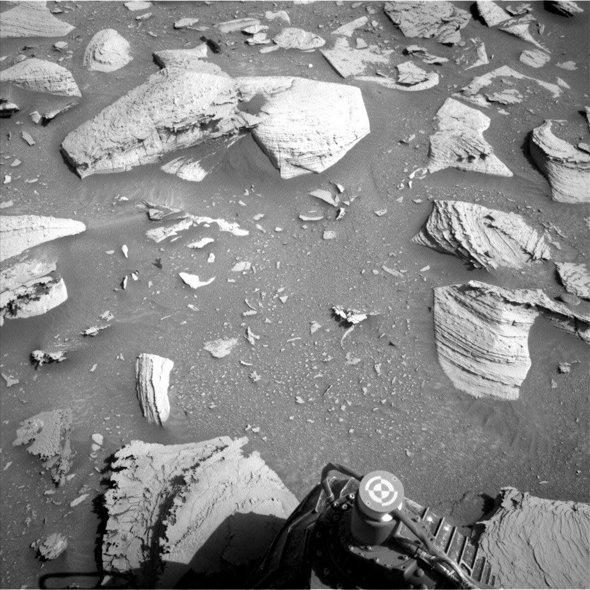
The first sol of this two-sol plan includes a ChemCam LIBS observation of target “Pants Pass” (a layered portion of a block of bedrock) and a long-distance RMI of “Kukenan.” Next, Navcam will execute a line-of-sight activity and Mastcam will acquire drive direction imagery. We then have a couple of diagnostic activities for Mastcam’s filter wheel. Prior to our evening contact science on Sol 3962, Mastcam will also document the workspace to support future contact science with DRT. Then, MAHLI will image the two contact science targets as well as the MAHLI and APXS calibration targets. The first sol ends with APXS integrations on targets “Blackcap Mountain” and “Burnt Mountain,” two dark-toned portions of the block of bedrock.

On the second sol, Curiosity has a morning science block with a ChemCam LIBS observation of target “Charybdis” (layered bedrock) and a long-distance RMI mosaic of Peace Vallis. Mastcam will also document “Charybdis” and Navcam will obtain a dust devil movie. (Note for Greek mythology enthusiasts: We have investigated a target named “Scylla” in the past, but the Rover Planners will continue to drive Curiosity along the MSAR (Mount Sharp Ascent Route), so fortunately Curiosity should not find itself between Scylla and Charybdis in the future.)

With the additional workspace imagery planned today, we will hopefully be able to utilize the DRT in the weekend plan and acquire some compositional data and imagery of dust-free bedrock!

September 25, 2023

Sols 3957-3959: Curiosity the Cautious Rover!

Written by Catherine O'Connell-Cooper, Planetary Geologist at University of New Brunswick
Left Navcam image taken on sol 3955 by the Curiosity rover, showing the LIBS target “Thor Valley” on the left hand side.

Left Navcam, sol 3955, showing the LIBS target “Thor Valley” on the left hand side. Credits: NASA/JPL-Caltech. Download image ›

Earth planning day: Friday, September 22, 2023

When I opened the workspace imagery this morning, I was happy to see some nice big rock outcrops in reach of the rover and started to pick some nice targets for contact science with APXS, before realizing that one of the rear wheels is perched on a rock. Sure enough, the drive had cut short when the rover detected it had driven over an unexpectedly large rock. The terrain here is tough, lots of boulders to clamber over. Sometimes the rover detects that the boulders are a problem and cuts the drive short, to await further instructions from Earth and avoid any damage. We are all eager to get onto the next workspace, and these unexpected stops can be frustrating, but stops like these have helped keep Curiosity safe and roving for over 11 years now.

Fortunately, this is nearly always an excess of caution on the part of Curiosity and doesn’t involve any fancy footwork (wheelwork?!) to get going again. This was the case today, and we were able to plan to recover the rest of the 28 metre drive. We will get there eventually, and thanks to our cautious Martian rover, in one piece!

Unfortunately, having the rear wheel perched on a boulder meant that getting the arm out for contact science was considered to be an unnecessary risk, so the APXS and MAHLI teams got to stand down and start their weekend early. As ChemCam does not need to move the arm to analyze, the ChemCam team planned two LIBS activities (using the laser) looking at some small features in the rocks. We have been seeing lots of thin platy resistant features in recent workspaces, such as this one “Little Pothole Lake” from sol 3955. The ChemCam team members were happy to be close enough to get LIBS on “Hammil Valley,” a thin fin or edge of a platy layer on the left-hand side of the workspace. In contrast, the second LIBS target (“Thor Valley”) analyses some remnants of what appears to be a thicker resistant layer. You can see these on the large light toned block on the left-hand side of the Navcam image for this blog. These will also be imaged by Mastcam to provide colour images of the two targets. ChemCam will take an RMI (remote image) of some amazing sedimentary layering in “Whaleback,” about seven metres away from the rover. Mastcam will image the upper Gediz Vallis ridge, looking at the path ahead along the MSAR (Mount Sharp Ascent Route) and as part of the ongoing campaign to characterise this ridge. Mastcam will then take a nearfield (i.e., close to the workspace) mosaic of a trough, looking at its geometry and the way the sand is distributed across the trough.

Keeping the arm stowed does not limit environmental monitoring activities - it can actually allow the environmental theme group (ENV) to add even more activities, so today ENV have a very busy plan. There are several Navcam activities, including suprahorizon and zenith movies, a “sky survey” and a large dust devil survey. In addition to these (plus more routine DAN and REMS activities), there is a special SAM methane experiment at dawn of the third sol.

Hopefully, our 28 metre drive will execute successfully, and when I open Monday’s workspace, I will see a fantastic new workspace!

September 25, 2023

Sols 3960-3961: Big Fan of Rock Bands

Written by Alivia Eng, Graduate Student at Georgia Tech
This image was taken by Left Navigation Camera onboard NASA's Mars rover Curiosity on Sol 3958.

This image was taken by Left Navigation Camera onboard NASA's Mars rover Curiosity on Sol 3958. Credits: NASA/JPL-Caltech. Download image ›

Earth planning date: Monday, September 25, 2023

Despite a few bumps in the road, Curiosity tenaciously pushed on and has finally arrived at the intriguing light- and dark-toned bands. I am sure that I can speak for many of those planning today when I say that I was eager to investigate new targets- especially in preparation for our next drill. Rocks immediately in front of the rover, known as the ”workspace," are primarily light-toned and rough. Too rough, in fact, to employ the Dust Removal Tool, much to the dismay of the team who had been hoping to include a brushed bedrock target since we haven’t been able to perform contact science in seven sols. It is important to consistently acquire brushed bedrock measurements so that we can assess any changes along Curiosity’s traverse without that pesky dust in the way.

Given that the alternating light- and dark-toned bands are (1) so visually distinct, (2) show Mg-sulfate signatures from orbit, and (3) are our next drill target, Curiosity is set to be busy characterizing these rocks as much as power allows. On sol 3960, Curiosity will unstow its arm to use the Alpha Particle X-Ray Spectrometer (APXS) and Mars Hand Lens Imager (MAHLI) to investigate “Silver Spur," a bedrock target (albeit unbrushed). Then ChemCam will fire a laser at a rock named “Larkspur” to reveal its composition. ChemCam team member Dr. William Rapin and I advocated for Larkspur given the ambiguous grey splotches. Thanks to some sharp shooting by the ChemCam team, we are able to plan for the laser to shoot across both the grey splotches and the lighter-toned bedrock, hopefully giving insight on how this feature formed. Before ChemCam turns off on sol 3960, it will also acquire a long-distance remote micro-image (RMI) of Peace Vallis, a valley on the northern rim of Gale crater. Mastcam will then boot up to document the spot on Larkspur that ChemCam shot and a flaky-looking rock, named “Jigsaw Pass,” right next to the front right wheel (seen in this blog’s image). “Coyote Flats,” which encompasses an area in a light-toned band that we hope to reach after our next drive, will also be documented by Mastcam; and the Navigation Camera (Navcam) will acquire a cloud movie.

Following our relatively short drive on sol 3690, Curiosity will proceed with Post-Drive Imaging (PDI) which includes Navcam and Mastcam mosaics to inform our next day of planning. With such a busy sol, this hardworking rover needs a good night’s rest to recharge. Once Curiosity wakes up on sol 3961, it will engage in autonomous activities to select targets and fire ChemCam’s laser so that we have data on the new workspace upon the next planning day. Lastly, Curiosity will close this shift by capturing another cloud movie with Navcam.

September 22, 2023

Sols 3955-3956: Curiosity Needs an Altitude Adjustment

Written by Michael Battalio, Planetary Climatologist at Yale University
This image was taken by Right Navigation Camera onboard NASA's Mars rover Curiosity on Sol 3952.

This image was taken by Right Navigation Camera onboard NASA's Mars rover Curiosity on Sol 3952. Credits: NASA/JPL-Caltech. Download image ›

Earth planning date: Wednesday, September 20, 2023

Curiosity speeds towards an exciting new region, specifically close to an area that, from orbit, has visible light and dark banding. Our hope is that within a few more drives we may find a new target for Curiosity to drill. In preparation for an exciting new campaign of drilling, the team will be performing contact science on nearby bedrock. Unfortunately, over the last two sols, Curiosity temporarily did not know its orientation, so it could not safely move its arm or mast or drive. As a result, some imaging and arm activities were prevented, and the drive planned on Monday was not performed. Fortunately, the engineering team understands these sorts of issues since they have happened and been recovered from before. Hiccups like this are not dangerous themselves, as they instead protect the rover. As a result, Curiosity remained in the same location from earlier in the week.

Nevertheless, the team took this opportunity to further study several targets first targeting in the plan on Monday and repeat the activities that were not performed due to the issues. MAHLI will image "Sugarloaf," composed of bedrock, and "Toms Place" to look at stratification. ChemCAM will also look at "Little Pothole Lake" and take long distance imaging of the Gediz Vallis ridge (see the recent press release on Curiosity reaching this milestone location). Finally on the second sol of this plan, Curiosity will take dust devil and cloud movies.

Not only is the team managing and troubleshooting the rover issues and preparing a new drill campaign but also looking much further ahead to the solar conjunction, whereby Mars passes behind the sun. During these three or so weeks, which will be in November this year, contact with Curiosity will be minimal, so the craft is on its own; however, planning for this event continued today to select all the activities for Curiosity to complete. Though limited in the kinds of activities in this low-contact period, Curiosity will remain busy.

September 19, 2023

Sols 3953-3954: On the Up and Up, the View Just Keeps Getting Better

Written by Ashley Stroupe, Mission Operations Engineer at NASA's Jet Propulsion Laboratory
This image was taken by Right Navigation Camera onboard NASA's Mars rover Curiosity on Sol 3950.

This image was taken by Right Navigation Camera onboard NASA's Mars rover Curiosity on Sol 3950. Credits: NASA/JPL-Caltech. Download image ›

Earth planning date: Monday, September 18, 2023

Coming in to planning today, we were greeted with another spectacular view back down Mt. Sharp and the distant crater rim visible through the haze (see the image). I am the TUL (Tactical Uplink Lead) today, but my trainee Kathryn is doing most of the work. We are continuing to drive southeast toward our next drilling location. In addition to contact science, targeted science, and driving, we are also doing some extra atmospheric observations because we are still seeing a lot of dust in the atmosphere.

Today’s 2-sol plan has most of the activities on the first sol of the plan to ensure that we get all the data down before we plan again on Wednesday. Curiosity begins her day with some contact science. We use the DRT brush to clean he target “Sugarloaf,” a standard bedrock target that is very flat and dusty. Rover Planners (RPs) like these flat targets because they are very safe and simpler to evaluate and command, and we can get very good results from brushing. Once clean (hopefully), we place the APXS on Sugarloaf for some short integrations. At the end of the first arm sequence, the arm is moved off to the side to be out of the way for some targeted imaging of the workspace.

With the arm out of the way, we turn to imaging. We begin with a multispectral image of the contact science target Sugarloaf and a corresponding image of the calibration target. Next we take a stereo mosaic of the target “Zagori,” a distant set of eolian bedforms that we’re now seeing from a new angle. We then turn to CHEMCAM LIBS to look at the target “Toms Place,” which is another target on the same bedrock block as Sugarloaf, and a long distance RMI image of a darker capping layer on GedizVallis. We follow that up with a Mastcam mosaic around Toms Place to look more closely at the layers and a Mastcam solar tau, which is an observation of the sun to measure the amount of dust in the atmosphere.

With the targeted imaging complete, we turn back to the arm to take MAHLI images of our Sugarloaf target. We then stow the arm to prepare for the drive. The drive is taking us about 34m in a relatively straight drive southeast toward the strategically planned route. The terrain continues to be a mix of rocks and sand, though the rocks and slopes are relatively benign; there aren’t a lot of sharp pointy rocks or big rocks and the tilts are below 15 degrees. After the drive, we take our standard suite of post-drive imaging along with some additional atmospheric images in the later afternoon. And, just after sunset, we take our standard post-drive MARDI image looking under the rover.

After a good night’s sleep, Curiosity wakes up for some untargeted science. We take several atmospheric observations, including another Mastcam solar tau, a Navcam line-of-sight of the norther crater rim and Navcam stereo dust devil movie. Then CHEMCAM runs AEGIS for some automated science of whatever looks the most interesting from our new location. And finally, in the late afternoon, we are taking some Navcam movies looking for clouds.

September 15, 2023

Sols 3950-3952: Dusty Skies in the Cloudy Season

Written by Conor Hayes, Graduate Student at York University
This image was taken by Left Navigation Camera onboard NASA's Mars rover Curiosity on Sol 3948.

This image was taken by Left Navigation Camera onboard NASA's Mars rover Curiosity on Sol 3948. Credits: NASA/JPL-Caltech. Download image ›

Earth planning date: Friday, September 15, 2023

Some days, the process of preparing a plan to be uplinked to our intrepid rover goes beautifully smoothly, with everyone and everything working together in near-perfect synchrony. Other days, it can feel like the entire universe is conspiring against us. Planning today was definitely one of the latter. Our drive from Wednesday's plan came up about four metres short of the intended destination, meaning that we didn't have the images required to determine whether or not it is safe to unstow the arm over the weekend. Consequently, we had to pivot today's plan to one focused on imaging. This isn't an unusual occurrence; however, there was a small software problem here on the ground that prevented us from accessing the higher-resolution images that we need to select imaging targets until quite late in the planning timeline.

Fortunately, all of the images did eventually arrive, so we didn't have to pull any observations. It's a good thing too, since we are planning quite a few! Here over in the Atmosphere and Environment Science Theme Group (ENV), we're used to our planning days being a little more low-key than those of the Geology and Mineralogy Science Theme Group (GEO). Because the atmosphere is all around us, we can pretty effectively create our plans in advance without having to worry about where we'll end up after driving or what interesting rocks we'll be able to safely touch. We are also always aware of the fact that geology is Curiosity's primary mission, so we try to keep our time requests to the minimum that is necessary to accomplish our own science objectives.

On occasion, we do have to request more time than usual, as we had to today thanks to the confluence of multiple events. First, there has been more dust in the atmosphere than we're used to seeing at this time of year, so we added a "tau" observation, where we take images of the Sun using Mastcam to measure how much dust is in the air, to each sol of the plan in order to track how this excess dust evolves over time. Second, we were due for a "passive sky" observation where we use ChemCam and APXS to measure the composition of the atmosphere. This is one of the longer observations that we have, so it can really limit the amount of science time left over for GEO on a particular sol. Happily, the rover's batteries are nice and charged up, so both ENV and GEO were able to fit in almost all of what we wanted without having to negotiate what should be sacrificed in favour of higher-priority observations. Power can sometimes be challenging during the winter since we need to dedicate more of it to keeping the rover warm, so it is always nice when it cooperates with us.

Our plan today starts off with a couple of ENV activities. In addition to a tau measurement, we also have a 21 frame movie pointed off towards a nearby sand patch to see if we can catch the wind blowing some of the sand around. We then jump into some GEO observations, including Mastcam imaging of "Lodgepole," a layered block with some resistant fin features (which you can see in the cover image above, just left of centre), and a Mastcam mosaic looking towards our potential next drilling location up Gediz Vallis. ChemCam will continue its RMI imaging of the upper Gediz Vallis ridge and will target "Scylla" with LIBS, the results of which will be documented by Mastcam.

The rover then gets to sleep overnight before waking up for another sol of activities, starting off with another Mastcam tau and Navcam cloud movie, as well as Mastcam imaging of some polygonal fractures on the target "Seven Gables." ChemCam LIBS and Mastcam will then once again collaborate on the target "Lupine." We will then drive to our next location before going to sleep again.

When we wake up, we will once again begin the sol with a Mastcam tau and a Navcam 360 degree survey for wind-induced dust activity around us. Because we don't know exactly where we'll end up post-drive, we can't select another LIBS target ourselves, so we'll let the rover do that itself. The final big activity for the third sol of this plan is the aforementioned ChemCam passive sky for ENV.

As is always the case with weekend plans, we wrap up with some early morning ENV activities right before we hand over into Monday's plan. These include a Navcam Phase Function Sky Survey, which takes nine three-frame movies forming a dome around the rover to look at clouds across the entire sky, two eight frame cloud movies looking directly overhead and just over the horizon, another Mastcam tau, and Mastcam and Navcam images of the north crater rim.

Of course, we can't neglect to mention the hard work of REMS, RAD, and DAN, all diligently taking their routine measurements as we enjoy the weekend.

September 13, 2023

Sols 3948-3949: A Rocky Road, or Two!

Written by Susanne Schwenzer, Planetary Geologist at The Open University
This image was taken by Front Hazard Avoidance Camera (Front Hazcam) onboard NASA's Mars rover Curiosity on Sol 3946.

This image was taken by Front Hazard Avoidance Camera (Front Hazcam) onboard NASA's Mars rover Curiosity on Sol 3946. Credits: NASA/JPL-Caltech. Download image ›

Earth planning date: Wednesday, September 13, 2023

Our view out of the window, in this case the front hazard camera, is spectacular today, as you can see above. Regular readers of the mission updates will know that this rocky road has caused us problems in our driving lately, but today it all went smoothly. We are planning another 30 metre drive in today’s plan, so let’s hope Mars will read the script (and agree to it!). While we are planning, this blogger needed some sugar… and so I am looking at two rocky roads, one on Mars, and one dropping chocolate all over my computer (shhht, don’t tell anyone!). The Martian one clearly looks more beautiful, though, and I once again imagine what it would be like to walk up that hill, look at the layering in the walls.

In the current parking position, we have entered a new quad of the map, the Bishop quad named after the small town of Bishop. Bishop lies in the shadow of California’s Sierra Nevada mountain range, and is the starting point of many trips into the high Sierras from the east. That means, we have a large range of new names themed after the Sierras at our disposal. Curiosity will take an APXS and MAHLI image of the target we named “Mosquito Flat.” It is a rock with an interesting dark feature, which will complement the observations on the lighter toned bedrock Curiosity targeted in the past plans. ChemCam is targeting a diagenetic feature with its LIBS on a target called “Chocolate Peak” (nothing to do with the state of my computer keyboard, I promise, as this name refers to the 11,682 foot Chocolate Peak in eastern Sierras). ChemCam also looks at the Gediz Vallis Ridge with a long distance RMI observation. ChemCam also has an AEGIS LIBS observation in the sol after the drive.

Mastcam has a multispectral observation of the DRT spot at “Mosquito Flat” in the plan, a documentation image on “Chocolate Peak” and two larger mosaics. One is directly to the starboard side of the rover to investigate all the laminations and diagenetic features we see in the area around us, and one on the Gediz Vallis Ridge, which continues to be an intriguing target that we learn more about as we get more images.

Atmospheric observations with a focus on the opacity of the atmosphere as well as DAN looking at the subsurface and a MARDI image round off the plan. Have fun on the rocky road, Curiosity.

September 12, 2023

Sols 3946-3947: Onwards to Bishop

Written by Lauren Edgar, Planetary Geologist at USGS Astrogeology Science Center
This image was taken by Right Navigation Camera onboard NASA's Mars rover Curiosity on Sol 3944.

This image was taken by Right Navigation Camera onboard NASA's Mars rover Curiosity on Sol 3944. Credits: NASA/JPL-Caltech. Download image ›

Earth planning date: Monday, September 11, 2023

Curiosity is making good progress towards our next potential drill location in a region of alternating light and dark banding. Before we get there, we’re collecting a lot of great contact science on these blocks of broken up bedrock to document compositional and textural changes. Today’s two-sol plan includes contact science and driving on the first sol, followed by untargeted remote sensing on the second sol.

I was on shift as SOWG Chair today, and it was a remarkably smooth day of planning – I love it when the plan comes together so well and fits within our power, data, and time of day constraints while accomplishing some great science. The plan starts by using the DRT to expose a fresh surface at the bedrock target “Antikythera,” followed by APXS to assess its chemistry. Then we’ll use ChemCam and Mastcam multispectral to collect some additional chemistry observations on the same target. The team also planned several Mastcam mosaics at “Delphi,” “Mycenae,” and “Zagori” to assess the local bedrock and some resistant fins, and to document a nearby ripple field with an edge-on view of the bedform crests. We’ll also use the ChemCam RMI to acquire a long distance mosaic looking back towards Peace Vallis, and take a Mastcam tau observation to assess atmospheric opacity. In the afternoon, MAHLI will image the DRT target “Antikythera,” followed by a ~26 m drive and imaging to prepare for the next plan. The second sol includes an autonomously selected ChemCam target, and Navcam observations to assess dust in the atmosphere and search for dust devils.

The planned drive should put us in a new mapping quadrangle, informally known as the Bishop quad. Our informal naming convention is to divide up the exploration region into square quadrangles (0.025 degrees of latitude or longitude on a side) and each quad is assigned a name of a town with a population less than 100,000 people. As Curiosity investigates targets within a quad, we assign names to targets that correspond to geological formations and features from near that town on Earth. Bishop California is located in Owens Valley, and is the starting point for trips into the High Sierra, including some awesome geology. It feels like a fitting name for the next part of Curiosity’s ascent of Mt. Sharp!

For more information on how and why rover teams name features on Mars, check out this recent news story.

September 11, 2023

Sols 3943-3945: Another Martian Weekend

Written by Alex Innanen, Atmospheric Scientist at York University
This image was taken by Left Navigation Camera onboard NASA's Mars rover Curiosity on Sol 3941.

This image was taken by Left Navigation Camera onboard NASA's Mars rover Curiosity on Sol 3941. Credits: NASA/JPL-Caltech. Download image ›

Earth planning date: Friday, September 8, 2023

Curiosity continues its bumpy travels across the bedrock blocks this weekend. We got the good news this morning that we would be able to safely do contact science in the plan! This means that we have a very familiar weekend plan – contact science on the first sol, a drive on the second sol, and remote science on the third sol. We’ve had this general structure on countless weekends throughout Curiosity’s travels, but the ever-changing landscape around us means that there’s always something new to see.

The two contact science targets are both on the same block close beside the rover. ‘Hydra,’ which will be brushed with the DRT before being examined by both APXS and MAHLI, is a patch of bedrock which is relatively free of the nodules that can be seen on other bedrocks around. APXS and MAHLI will then turn their attention to ‘Dodoni,’ a raised resistant feature. That’s not all for the first sol though – ChemCam and Mastcam are continuing to document the upper Gediz Vallis Ridge, as well as LIBS on another nearby bedrock, ‘Thassos.’ Mastcam is also looking back at the Orinoco butte and in the later afternoon looking back closer afield at a layered block called ‘Rouskio.’

We’re driving away on the second sol, but before that we’re getting over an hour of science. ChemCam is doing LIBS of a dark vein on the same block as Thassos known as ‘Antiparos,’ and two long distance mosaics looking back towards the eastern crater rim. Mastcam is taking a look at the nearby workspace as well as the contact and LIBS targets, and another resistant target, ‘Milos.’ ENV is also getting in on the pre-drive science with a dust devil movie looking at a ripple field, and a line of sight, capturing the amount of dust between us and the crater rim.

Our third and final sol picks up some remote science. We have a 360 degree dust devil survey as well as a midday suprahorizon cloud movie. ChemCam will also use AEGIS to select a target for imaging. After a busy first two days of the plan, Curiosity gets to do plenty of napping on this last sol, but we’ll wake up for an early morning ENV block with our normal cloud movies and characterisation of the atmospheric opacity.

September 7, 2023

Sols 3941-3942: Follow the Red Bumpy Road

Written by Sharon Wilson Purdy, Planetary Geologist at Smithsonian National Air and Space Museum
This image was taken by Right Navigation Camera onboard NASA's Mars rover Curiosity on Sol 3940.

This image was taken by Right Navigation Camera onboard NASA's Mars rover Curiosity on Sol 3940. Credits: NASA/JPL-Caltech. Download image ›

Earth planning date: Wednesday, September 6, 2023

Today I served on the rover science operations team as the Geology theme group Keeper of the Plan, otherwise known as the “GKOP.” The GKOP operates the software that is specifically designed to help the science team build a plan of geology-focused observations that fit within the pre-determined duration of the science blocks on each sol.

The rover is currently driving across bumpy terrain consisting of rounded bedrock sticking up between dark sand and drift as she drives south, and slightly uphill, along the Mt. Sharp Ascent Route. Due to the rugged ground, the rover sometimes ends her drive with a wheel or two perched on a rock. When that happens, as it did today, we are unable to safely unstow the arm to do contact science. We pivoted and planned a ChemCam LIBS observation of target “Eleusis” to characterize the composition of smooth bedrock in our workspace. A nearby exposure of bedrock was documented by a Mastcam stereo mosaic of the “Kechries” target. We also took a Mastcam stereo image of a nearby trough to investigate the interaction between the sand and bedrock. Off in the distance, we planned a Mastcam multispectral image and a long distance ChemCam RMI image of “Kukenan” to further characterize and document the varying textures and layers within the butte.

In addition to a 23 meter (~75 feet) drive in this 2-sol plan, Curiosity will collect environmental data including surveys to monitor dust devil activity, a movie to monitor cloud movement, and a solar tau to measure the optical depth of the atmosphere and to constrain aerosol scattering properties. The science team ended the day with a look-ahead to Curiosity’s weekend plan – with lots of images to take and data to collect it’s never a dull moment for this rover on Earth or on Mars!