November 1, 2022

Sol 3640: Can't Touch This

Written by Michelle Minitti, Planetary Geologist at Framework
This image was taken by Left Navigation Camera onboard NASA's Mars rover Curiosity on Sol 3639.

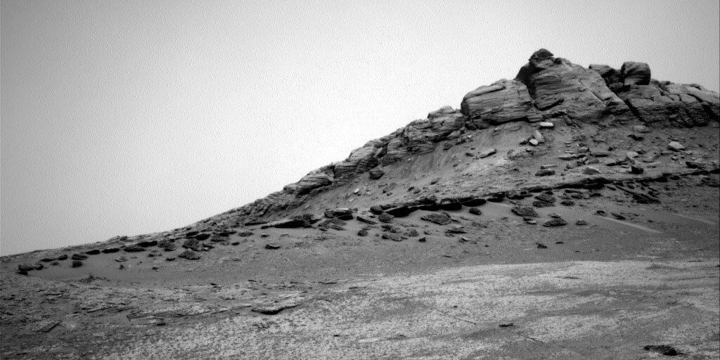
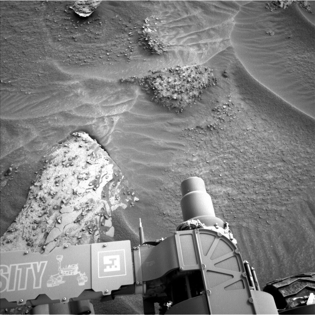
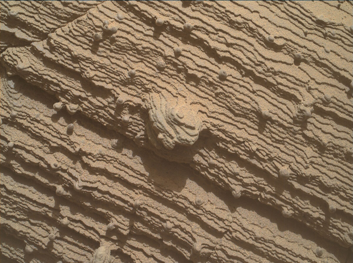
This image was taken by Left Navigation Camera onboard NASA's Mars rover Curiosity on Sol 3639. Credits: NASA/JPL-Caltech. Download image ›

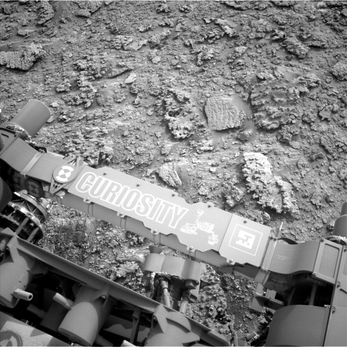
We arrived at the spectacular workspace pictured above, but what made it spectacular - rocks - is what also made it tricky. Our left front wheel was propped up just enough on one of the lovely and interesting rocks to make it unsafe to unstow the arm. Thus, as Deirdra, one of my planning partners said - it felt like Mars was taunting us with some early 1990s MC Hammer. Fortunately, the rover planners were confident in finding a way to reposition the rover to stabilize us enough to get the arm out, so that small maneuever was added to today’s plan. Our fingers are crossed we have better luck tomorrow!

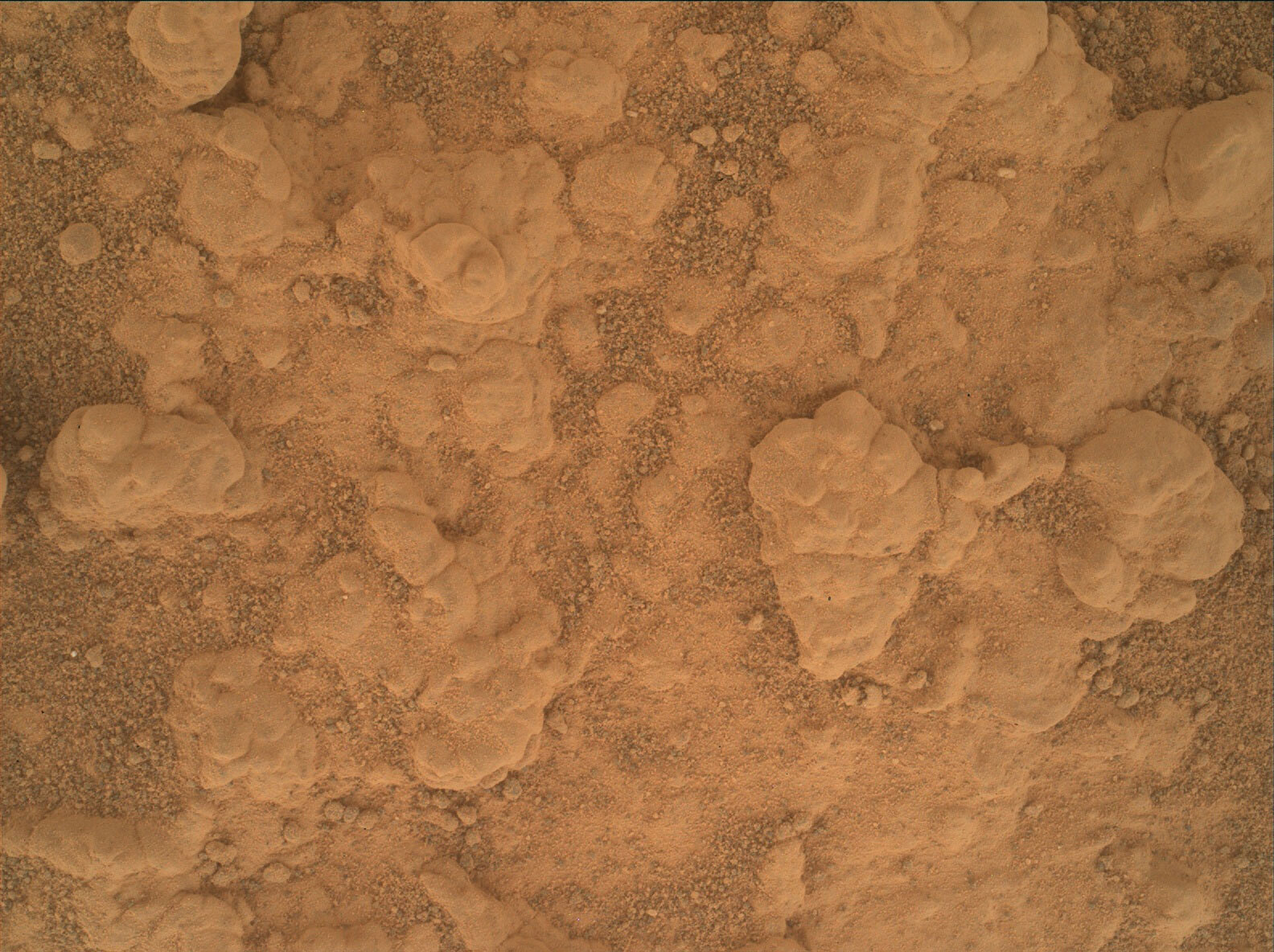
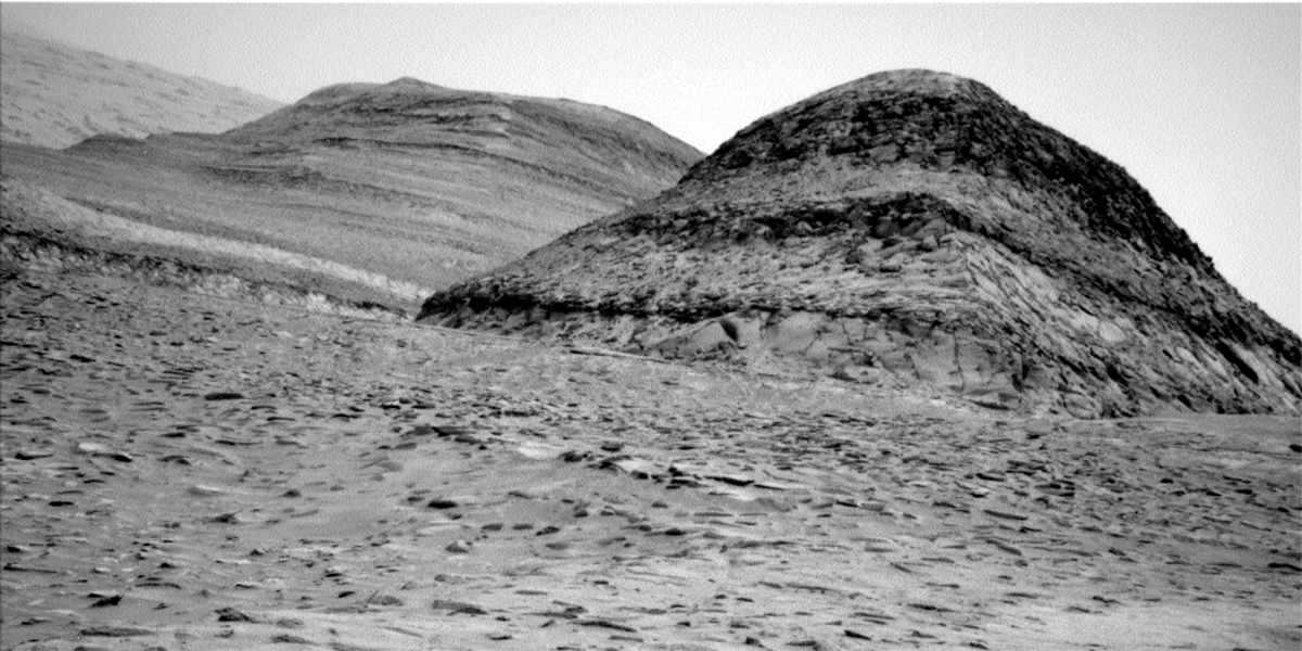
While we could not apply MAHLI or APXS to the rocks ahead of us, we had no restrictions, short of overworking uplink teams, on using Mastcam and ChemCam. We took full advantage of our additional time to image our amazing surroundings. We planned a ChemCam raster along one of the notable resistant ridges that span the workspace blocks, on target “Saracura.” We used ChemCam RMI to image a stack of the layers at the edge of the marker band, at target “Curecurema.” Layer-parallel imaging like this is a terrific way to interrogate the mechanisms that formed those layers. There were so many interesting textures on the workspace rocks that we could not help but wonder if chemistry had anything to do with them. To investigate this, we planned Mastcam multispectral observations of two targets, “Patua” and “Tucano.” Mastcam will also cover the scene with multiple large stereo mosaics. One will capture the marker band extending away from us to the south, another will cover the workspace blocks, and a third will image blocks similar to those in the workspace, but out of reach, at target “Benevenuto.” We still managed time for a Navcam dust devil survey, and DAN passive and active measurements before and after we reposition the rover, respectively. RAD and REMS run throughout the plan.

October 31, 2022

Sol 3639: Trick or Treat!

Written by Kristen Bennett, Planetary Geologist at USGS Astrogeology Science Center
This image shows Curiosity's nameplate and was taken by Left Navigation Camera onboard NASA's Mars rover Curiosity on Sol 3638.

This image was taken by Left Navigation Camera onboard NASA's Mars rover Curiosity on Sol 3638. Credits: NASA/JPL-Caltech. Download image ›

Today’s planning felt like we were trick or treating on Mars, just in time for Halloween! The image above shows part of the workspace that was revealed in front of Curiosity today. There were a variety of rocks available to look at and picking just one was very challenging! One reason why this was tricky was because none of these rocks appeared to be “in place.” This means that the rocks in the workspace likely tumbled down from higher up a slope. It is hard for geologists to interpret the results from a rock if we don’t know the context of where it came from. Tricky! However, scientists spotted a treat in the form of in place rocks off to the right of the rover. The team decided to prioritize driving over to those rocks so we can understand the context of the rocks we study in more detail. Before we drive off, the team decided to get a few measurements on rocks in the workspace to get a small sample of the variety we observe. We had to pick just one or two rocks to analyze - kind of like picking just one or two pieces of candy from your trick or treat bag. “Nicara” was a smooth, dust-free target that was selected for contact science (APXS and MAHLI), and “Caicubi” was a nodular rock targeted by ChemCam.

There were also several Mastcam mosaics in today’s plan, including additional imaging of the workspace to obtain higher resolution images of the variety of rocks that were present. There were also Mastcam mosaics targeting the marker band that extended away from the rover both to the south and to the north. The drive was planned along the marker band to the north, and hopefully tomorrow Curiosity will be sitting at a new location along the marker band to investigate the next treat!

October 31, 2022

Sols 3637-3638: Let the Detour Begin – To Gediz Vallis Ridge We Go!

Written by Catherine O'Connell-Cooper, Planetary Geologist at University of New Brunswick
Right navigation camera, showing the Marker Band as a continuous dark thin layer running from left to right (but thinning out on the left).

Right navigation camera, showing the Marker Band as a continuous dark thin layer running from left to right (but thinning out on the left). Credits: NASA/JPL-Caltech. Download image ›

This is a two sol weekend plan, as Saturday is a soliday. On the first sol, we characterize the workspace in front of us and then drive on the second sol to a new workspace. We are now officially on our detour, a short round trip to image and capture geochemistry of the “Gediz Vallis ridge” up on the pediment, before coming back down to the “Marker Band valley” and rejoining the MSAR (Mount Sharp Ascent Route). This detour will allow us to access some of the area we’d planned to visit before getting turned around by the ‘gator-back’ terrain on the Greenheugh pediment. For this part of the campaign, we are prioritizing driving, getting to our destination as fast as we can, but imaging as we go and marking areas of interest for contact science as we come back down. Today’s drive begins our ascent, taking us up a 16 degree slope to a ridge which will give us good views of the terrain ahead.

This drive also brings us closer to the contact with the Marker Band itself, a relatively thin band of material, traceable throughout this area (see accompanying image), but whose composition and origin are unclear. It may be in our workspace or just beyond after the weekend drive, so the end of drive imagery from the weekend plan will be very eagerly awaited. This imagery includes a very large Mastcam mosaic (48 images) along the potential contact with the Marker Band and some bedrock slabs which may be part of the Marker Band.

Before we drive, we first get as much information as possible from this location. The workspace had bedrock and abundant small grey pebbles or nodules, some of which were loose on the bedrock but some of which appeared to be in place. We managed to find a brushable bedrock spot for the first time since leaving the Canaima drill site, which helps APXS characterize the bedrock free of dust and sand. APXS will also analyze a cluster of the pebbles. MAHLI will image both the brushed bedrock (“Catrimani”) and the cluster (“Marari”) targets. A Mastcam multispectral image on Catrimani rounds out that set of observations. ChemCam is using LIBS to analyze a nodular feature (“Cumate”), a layer of more resistant material (“Wai Wai”) and some more typical bedrock (“Au Au” or “Gold Gold” as we nicknamed it). Mastcam will image both ChemCam targets.

Mastcam will also take several larger images of material just beyond the workspace. “Iniquiare” captures a set of large fractures. “Linepenome” is a set of three images centred on a large float block and the sorting of sands around this feature.

We also continue our environmental monitoring. Mastcam is acquiring a pair of tau measurements and a sky survey to monitor dust levels. REMS and DAN will compliment these with their usual cadence of temperature checks (REMS) and routine hydrogen checks (DAN).

October 26, 2022

Sols 3635-3636: Lumpy Bumpy

Written by Michelle Minitti, Planetary Geologist at Framework
Using an onboard focusing process, the Mars Hand Lens Imager (MAHLI) aboard NASA's Mars rover Curiosity created this product by merging two to eight images previously taken by the MAHLI, located on the turret at the end of the rover's robotic arm.

Using an onboard focusing process, the Mars Hand Lens Imager (MAHLI) aboard NASA's Mars rover Curiosity created this product by merging two to eight images previously taken by the MAHLI, located on the turret at the end of the rover's robotic arm. Credits: NASA/JPL-Caltech/MSSS. Download image ›

In today’s plan, we got to exercise our combined APXS-MAHLI touch and go capability. Now that our days on Mars are starting a bit earlier thanks to Earth rising earlier in the morning sky, APXS gets a cooler time to operate on days we also drive. So the APXS-MAHLI teams are back to being regular partners in exploration once again. Today’s workspace was much like our last one, lumpy and bumpy, as seen in the MAHLI 5 cm image above from our last workspace (for scale, the image is ~5 cm wide). Lumps and bumps like this are interesting because they suggest the bedrock did not sit around idly after formation - something stuck the grains of this rock a bit more tightly together than their neighboring grains, leading to more resistant lumps. APXS looks for the chemical fingerprint of what might have caused the lumps, and MAHLI gets to gaze at their intricate textures. Together we targeted a similar feature in today’s workspace, called “Mau.” MAHLI also had a look at linear depression in the sand around the workspace bedrock that had an interesting distribution of pebbles around its perimeter, called “Univini.”

ChemCam also got in on the lumpy bumpy fun, targeting a different lump from APXS and MAHLI at “Cumate.” They will also capture the ever-nearing marker band outcrop with a 12 image RMI mosaic. Mastcam will acquire an expansive stereo mosaic of the amazing scenery that we are driving into, and a single multispectral footprint within that scene on an apparently bright block, called “Maraca."

Our drive will continue our beeline west toward a spot where we can access the marker band and points beyond. After the drive, ChemCam will acquire an autonomously-targeted raster to give us an early look at our weekend home for science. Navcam will look for dust devils and clouds. Throughout the plan, we have multiple DAN passive measurements, punctuated by two DAN active measurements. REMS and RAD run steadily across both sols.

October 24, 2022

Sols 3633-3634: Trying to Avoid Nodules

Written by Kenneth Herkenhoff, Planetary Geologist at USGS Astrogeology Science Center
This image was taken by Left Navigation Camera onboard NASA's Mars rover Curiosity on Sol 3631.

This image was taken by Left Navigation Camera onboard NASA's Mars rover Curiosity on Sol 3631. Credits: NASA/JPL-Caltech. Download image ›

The long Sol 3631 drive went well, leaving the rover near exposures of nodule-rich bedrock. Because we have examined the chemical composition of nodules recently, a goal for today's planning was to find patches of bedrock that are relatively nodule-free in order to look for changes in the "background" bedrock. So the Sol 3633 plan starts with a couple APXS integrations on "Balata," a bedrock exposure with fewer nodules than other blocks in front of the rover. Then ChemCam will fire its laser at "Apon," avoiding nodules on a patch of bedrock closer to the rover. Today I focused on planning a long-distance RMI mosaic of bedrock exposures about 140 meters away named "Chenapau," just right of center in this image.

After ChemCam is done, Mastcam will acquire mosaics of both ChemCam targets, plus a 5x2 stereo mosaic of sedimentary structure at "Ananaliua" and a 3x2 stereo mosaic of a change in surface texture at "Bolivar." Then MAHLI will take close-up images of Balata before the arm is stowed and the rover drives on toward the west. After the usual post-drive imaging, the arm will be deployed again to allow MAHLI to take an image of the REMS UV sensor to monitor the distribution of dust on that instrument. Later that afternoon, Mastcam will image the Sun to measure the amount of dust in the atmosphere above the rover and acquire a 3x2 left-eye mosaic of the new arm workspace in front of the rover. Finally, Navcam will search for clouds and dust devils, and MARDI will again image the ground behind the left front wheel during twilight.

On Sol 3634, Mastcam will measure the dust in the atmosphere again and the rover will autonomously select a target for another ChemCam LIBS observation. ChemCam will then look up at the sky to look for changes in gas chemistry. In addition to the normal REMS, DAN and RAD measurements, Navcam will again search for dust devils. Then the rover will sleep overnight in preparation for more good work on Sol 3635.

October 21, 2022

Sols 3630-3632: Driving on the Sidewalk, MARDI-Style

Written by Catherine O'Connell-Cooper, Planetary Geologist at University of New Brunswick
This image was taken by Left Navigation Camera onboard NASA's Mars rover Curiosity on Sol 3628.

This image was taken by Left Navigation Camera onboard NASA's Mars rover Curiosity on Sol 3628. Credits: NASA/JPL-Caltech. Download image ›

We continue our drive through “Marker Band valley”, an area of high interest scientifically, due to strong evidence of sulfates from orbital mapping. In this area, the sulfates are typically magnesium rich (think Epsom salts!), with less evidence for the more common calcium rich sulfates we have been traversing across for over ten years.

We found some lovely bedrock in our workspace this morning, close enough to touch with APXS and MAHLI. The main bedrock slab (lower left in the above image) has two obvious textures – the bedrock itself and then a smooth layer, which can often represent a vein surface. As APXS Strategic Planner today, my job involved helping the geology theme group (GEO) to choose the best targets. We were not able to brush the bedrock here but did manage to find two spots relatively free of dust and sand: “Santa Silvia” is a typical bedrock target, whilst “Vista Alegre” focuses on the flat smooth surface. ChemCam is shooting a similar smooth target “Ita” along the same vein surface.

Just outside the arm reach, in the upper right of the above image, there is a very intriguing bedrock slab, with lots of rock fragments - some loose, some in place. These fragments are very abundant in this area but it’s not clear if these are pebbles or nodules (with concentrated sulfate composition, for example), so ChemCam is shooting the target “Mucajai” to see if they can shed light on the origins of the fragments.

In addition to imaging the ChemCam targets at this workspace, Mastcam will image “Maracaibo” and “Rorainopolis,” both acquired to examine rocks ahead of us in the Marker Band valley. Mastcam will also acquire a multispectral image of a light-toned soil “Calcara,” freshly scuffed in wheel tracks behind us, seen here to the left of the turret in this Left Navcam.

The environmental theme group (ENV) continue to document conditions within Gale crater, in particular looking at dust buildup in the atmosphere, using Mastcam “tau” measurements.

Finally, we have a long drive along the MSAR (Mount Sharp Ascent Route). The drive didn’t have any specific end points of interest to focus on. Instead, the rover planners were advised to drive as far as they could on the MSAR, so we are doing a 58-metre drive on the second sol of this weekend plan. That’s a considerably faster pace than we have done recently, as we searched for the optimal drill site (choosing “Canaima” in the end as our 36th drill hole on Mars). This long drive is paired with a MARDI “sidewalk” image- which is a continuous video shot along the whole length of the drive. At 58 metres, this one will be one of the longest sidewalk videos ever taken on the mission.

October 19, 2022

Sols 3628-3629: New Site, New Sights, New Science

Written by Alex Innanen, Atmospheric Scientist at York University
This image was taken by Left Navigation Camera onboard NASA's Mars rover Curiosity on Sol 3626.

This image was taken by Left Navigation Camera onboard NASA's Mars rover Curiosity on Sol 3626. Credits: NASA/JPL-Caltech. Download image ›

For the first time in a little while we’re at a new location after a drive in the last plan, which means new targets for the Geo team to investigate, and slightly different viewsheds for ENV to work with. Power was a bit tight, especially for the first sol with two hours of science time, a drive, and arm activities. Still, we managed to pack in lots of targeted science before driving away.

We’re staring the first sol with the first of the arm maneuvers, allowing APXS to get a look at a bedrock target called ‘Pacu.’ Pacu will also be the subject of a ChemCam LIBS observation, and ChemCam will be rounding out their sol’s imaging with a long distance mosaic of 'Los Brincos.' Mastcam is also getting in on the action, with the similarly named ‘Arapari’ and ‘Arapixi,’ as well as 'Baganara Island,' (part of which can be seen in the bottom left of the image above) and documenting Pacu. ENV is also surveying the location, trying to catch dust devils. Finally, MAHLI is returning to Pacu before we drive off.

Just because we’ve driven to a new location doesn’t mean we have to wait to plan more science. After driving in the middle of the plan, such as on the second sol in this plan, we can still do ‘untargeted’ science, which just means we don’t have the benefit of seeing exactly what our new location looks like. Because for ENV we don’t necessarily care as much about what’s right near to us, this means we can usually fit in a good number of observations. This time, that includes a suprahorizon cloud movie, a dust devil movie, a full tau observation and a line of sight at the crater rim. ChemCam is also using AEGIS to autonomously select a target for analysis.

October 17, 2022

Sols 3626-3627: Packing Up at the Canaima Drill Site

Written by Sharon Wilson, Planetary Geologist at the Smithsonian National Air and Space Museum
NASA's Mars rover Curiosity acquired this image using its Mars Hand Lens Imager (MAHLI), located on the turret at the end of the rover's robotic arm on Sol 3624.

NASA's Mars rover Curiosity acquired this image using its Mars Hand Lens Imager (MAHLI), located on the turret at the end of the rover's robotic arm on Sol 3624. Credits: NASA/JPL-Caltech/MSSS. Download image ›

Curiosity is focused on wrapping up the drill campaign at the Canaima site before hitting the road again.

Curiosity started out with an unexpected 10% surplus in energy known as a “power gift.” This two-sol plan will allow Curiosity to complete the Canaima drilling activities before driving away along the Mount Sharp Ascent Route (MSAR). One planned activity is to analyze the Canaima drill tailings, the pile of material that was excavated by the drill hole. ChemCam will analyze the drill tailings to compare the chemistry between the drill tailings and the drill hole. ChemCam will target the range of material that is visible in the tailings pile from the smooth, finer-grained material to the larger clods. MAHLI will image the drill cuttings for context with a single 5cm standoff image. APXS and MAHLI will team up on the target “Bacabal,” located on the same rock as the Canaima drill site, to provide more information and context on the bedrock. Mastcam will acquire stereo imaging of two new targets, “Pedra” (an unusual shiny float rock) and “Taxi” (cyclically bounded laminations in the rock near Canaima), in addition to taking images of the rover wheel tracks to look for changes relative to previously acquired images. ChemCam plans to use its long distance remote micro imager to re-image a nearby hill that contains a distinct marker band, and the rover will continue its usual environmental monitoring.

October 14, 2022

Sols 3623-3625: RAGE Against the Drill Fines

Written by Abigail Fraeman, Planetary Geologist at NASA's Jet Propulsion Laboratory
This image was taken by Mast Camera (Mastcam) onboard NASA's Mars rover Curiosity on Sol 3619.

This image was taken by Mast Camera (Mastcam) onboard NASA's Mars rover Curiosity on Sol 3619. Credits: NASA/JPL-Caltech/MSSS. Download image ›

We are nearing the end of our drill campaign activities at Canaima, and this weekend we are planning to analyze the drilled sample with the SAM instrument's gas chromatograph and mass spectrometer (GC-MS). Like the CheMin X-ray diffraction and SAM Evolved Gas Analysis experiments, the SAM GC-MS analysis will provide additional data about the rock’s composition. GC-MS in particular is great at showing the types of organic molecules that might be present. Since this is the last time we need to deliver drilled sample to our onboard "chemistry lab instruments," we'll also attempt to dump sample material that remains in the drill bit assembly onto the ground. In order to preserve the life of the braking mechanisms on Curiosity's arm, the engineering team at JPL developed a new technique for dumping samples that is gentler on the arm (no percussion) with the charming acronym of RAGE, or "Rotate to Agitate Granules for Expulsion." So we'll be RAGEing on Mars this weekend in between all of the science.

With the power-hungry SAM activities, we're only planning a short amount of time for additional science. We'll collect ChemCam observations on two nearby rocks named "Manaus" and "Garimpo Cascavel," as well as a Mastcam multispectral observation of "Dress Island" and stereo mosaic of a nearby rock named "Peluca." ChemCam long distance RMI mosaics of Orinoco and several environmental science monitoring observations will round out the plan.

October 12, 2022

Sols 3621-3622: Planetary Power Puzzle

Written by Natalie Moore, Mission Operations Specialist at Malin Space Science Systems
MAHLI best focus image from a Sol 3605 six-frame mosaic of the “Tapirapeco” target on our drill site block.

MAHLI best focus image from a Sol 3605 six-frame mosaic of the “Tapirapeco” target on our drill site block. Credits: NASA/JPL-Caltech/MSSS. Download image ›

This morning’s planning kicked off with great news! Our Sol 3620 SAM data of the Canaima drill sample was interesting enough to proceed with planning a Gas Chromatograph Mass Spectrometry (GCMS) experiment. This type of activity is one of SAM’s specialties and can help characterize the chemistry of the rock we’re parked in front of, including the presence of compounds essential to life as we know it! (Necessary aside: molecular compounds considered essential to life are not biosignatures themselves and many can also be formed from geologic processes) However, planning GCMS on Mars requires a ton of power. The name of the game today was putting the power puzzle pieces together efficiently so we can still have the resources for a full weekend of planning next time (aka more remote sensing time to fill for my Mastcam uplink shift!).

For more SAM context, check out this annotated MAHLI selfie from our Mont Mercou drill campaign back in March 2021, showing what SAM looks like inside the rover and the location of SAM's inlet covers on the rover deck. For a closer view of SAM’s inlet covers, check out this Mastcam Left image of them after some of the Canaima drill sample was dropped off on Sol 3613. Safety trivia fact: while the arm does dynamic activities like dropping off sample to the rover deck, we always make sure the Remote Sensing Mast (RSM) is pointed away to avoid any drill fines blowing into the RSM’s many lenses. Drill fines are, well, finer than the sand/dust in the natural Martian environment and have a higher chance of being blown around. For this reason, we always take Mastcam high-resolution images of the drill hole after drilling and before using MAHLI on the ground again to determine if any drill hole fines have moved around.

Today’s plan includes actually opening one of the inlet covers to attempt dropping off the rest of our sample directly into SAM’s belly! Assuming all goes well, this is great news for MAHLI since she has been powered off since Drill Sol 2 on Sol 3612. Between drilling and dropping off the full sample, MAHLI/APXS ground activities are always precluded since the drill needs to be kept at a fixed orientation to avoid spillage. So as part of the MAHLI uplink team today, my job is pretty easy with no activities. Check out this throwback image of our pre-flight rover showing off her turret instruments!

For the rest of today’s power puzzle, the RSM was given ~2 hours of science time to split between ChemCam, Mastcam, and Navcam. After the experts spent some time moving activities around to get the best lighting and timing for power, we were still able to squeeze over 100 Mastcam frames in the plan! These frames will include an area we’ve imaged before to detect any changes (usually from wind), the sun and sky to continue monitoring increasing dust activity, and a lookback at the Bolivar and Deepdale buttes to document the many ChemCam Micro-Images at this drill site in color. Chemcam will shoot its laser at a target on the ground named “Vila Irabuia” for spectroscopy and take a 16-frame mosaic of distant ridges for stratigraphic investigations. Navcam will also investigate the increasing dust activity including a 9-minute movie to hopefully catch any dust devils on the horizon! Stay tuned for next plan where we’ll begin to wrap up the Canaima drill campaign so we can get back on that dusty trail.